Good morning. This is Doug Chabot with the Gallatin National Forest Avalanche Forecast on Thursday, March 28th at 7:00 a.m. Today’s forecast is sponsored by Montana State Parks and Highline Partners. This forecast does not apply to operating ski areas.
It is snowing in the mountains and the winds are strong. At 6 a.m. the The Bridger Range has a trace, Big Sky has 2” and 3-6” has fallen in the southern ranges. Wind is averaging 15-35 mph with gusts hitting 40-71 mph from the SW-NW. Temperatures are in the low 20s F. Snow will continue today and taper off early tomorrow. Wind will remain westerly and lessen to 15-25 mph sometime this afternoon. By morning the northern mountains will have 3-6” and the southern ranges will have 6-10”.
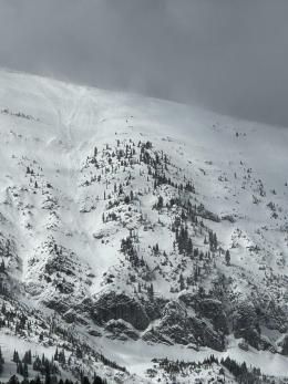
Wind-loading is the main avalanche concern in the Bridger and northern Gallatin Ranges. Fresh wind slab avalanches yesterday are a sign of what will occur again today; no Ouija board is required. Skiers in Frazier Basin saw many slides (observation) and Dave saw wind pluming snow off the ridge and recent avalanche activity in Argentina Bowl and near Saddle Peak (video, obs and photos). Snow will start to fall this morning and wind will continue loading slopes. Seek sheltered terrain and avoid terrain traps. Even shallow avalanches can be dangerous.
The avalanche danger is rated CONSIDERABLE on all wind-loaded slopes and MODERATE on all others.
Around Big Sky and all ranges south, new snow and wind-loading are the main avalanche concerns. Ian is in Cooke City and made a video standing in an 8’ deep pit, a visual treat given the low snow year (observation). He explains how new snow and wind are creating instability in the upper 1+ foot of the snowpack (pic 1, pic 2) and how the weaker, faceted snow near the ground is more difficult to trigger, but not impossible. Rocks sticking out in starting zones indicate shallow areas where a person could trigger a large and deadly slide.
Today is a day of active loading and the snowpack will be most sensitive to triggering, both naturally and by people. Wind is blowing at all elevations loading slopes. The weight of the new snow is starting to add up over the last 5 days (1” of snow water equivalent) and today is a day to travel wisely and conservatively. It is not always possible to identify exactly which slope or part of a slope has been wind-loaded, especially with poor visibility. Dangerous avalanche conditions are back. Be careful getting near avalanche terrain and be especially mindful of terrain traps.
The avalanche danger is rated CONSIDERABLE on all slopes.
If you get out please submit an observation. It does not need to be technical. Did you see any avalanches? How much snow is on the ground? Was the wind moving snow? Simple observations are incredibly valuable. You can also contact us by email (mtavalanche@gmail.com), phone (406-587-6984), or Instagram (#gnfacobs).
Upcoming Avalanche Education and Events
Our education calendar is full of awareness lectures and field courses. Check it out: Events and Education Calendar.
Loss in the Outdoors is a support group for those affected by loss and grief related to outdoor pursuits. Check out the link for more information.
If you have a few minutes, take a survey on how you interpreting avalanche forecast information in hopes of improving avalanche forecasting methods.


