Advisory Archive
The mountains received a dusting of new snow yesterday with westerly wind gusts of 40-50 mph. This morning, temperatures are in the single digits to low teens F with westerly wind at 15-20 mph. Temperatures will reach the high 20s F today with wind out of the west at 10-20 mph. Expect calm, dry weather and slightly warmer temperatures through the first half of the week.


Recent wet and warm weather has shifted to colder and dry. An historic week of snow in Cooke City ended yesterday afternoon with another 8-10” of snow. Yesterday morning, the mountains south of Bozeman to West Yellowstone received 3-5” of new snow, and the Bridger Range got 1-2”. Temperatures this morning are in the teens F and wind overnight was out of the west to southwest at 20-30 mph with gusts of 40-50 mph. Temperatures today will be in the high teens to 20s F. Wind will be out of the west at 25-35 mph. There is a chance for 1-2” of snow near Cooke City and a trace elsewhere before skies become partly sunny this afternoon.


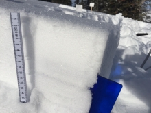
Cooke City is in the crosshairs of an atmospheric river. Over the past 24 hours, this area received 2.6” of SWE resulting in heavy snow up high and rain in town. The mountains around West Yellowstone also received heavy precipitation. Madison Plateau Snotel site is recording 1.7” of SWE over the past 24 hours with a temperature of 35 degrees. Most of this precipitation fell as rain. The mountains around Big Sky picked up .5” of SWE resulting in 2-3” of dense snow up high and rain in the base area. The Bridger Range did not receive much moisture, but has above freezing temperatures up to the ridge. Today, precipitation will continue in the southern ranges with another .5” to 1” SWE possible by tomorrow morning. The northern ranges will see a few inches of snow up high and rain down low. Snow levels will fluctuate between 7-9,000 ft. Winds will remain moderate to strong out of the W-SW. Fortunately, cooler and drier air will move into the area tomorrow.

In the past 24 hours the mountain around Cooke City received 8-10” of new snow. The southern Madison Range picked up 4-6” while the mountains near Bozeman, Big Sky and West Yellowstone picked up 1-3”. This morning, it’s still snowing lightly in the mountains around Cooke City and skies are partly to mostly cloudy elsewhere. Temps are in upper 20s to low 30s F and winds are blowing 15-40 mph out of the W-SW. Today, light snow will continue in the southern Mountains with 1-3” possible. Temps will warm into the low to upper 30s F and winds will remain moderate to strong out of the W-SW. More snow is expected tonight in the southern Mountains with an additional 2-4” possible by tomorrow morning. The mountains around Bozeman and Big Sky could see 1-3”.


In the last 24 hours 5-7” of snow fell in the northern mountains and Cooke City with 3-5” around West Yellowstone. Winds decreased yesterday but picked up this morning to 20-25 mph out of the west with gusts of 40-60 mph. Under cloudy skies mountain temperatures are in the mid-teens. Another inch may fall this morning with 4-6” more tonight. Today, winds will remain west and temperatures will reach the lower 20s under mostly cloudy skies.
Snowfall continued in the southern mountains yesterday with Cooke City and the mountains around West Yellowstone getting 10-12” of moist, heavy snow. Last night the Bridger Range picked up 5-7” with Hyalite and Big Sky getting 2”. West winds remain strong and are averaging 20-25 mph with frequent gusts of 50-60 mph. Mountain temperatures have cooled to 10F this morning. Today will remain cloudy and windy with snowfall returning later this afternoon and dropping 3-6” in the southern mountains and 2-4” in the northern ranges.

Since yesterday morning the mountains near Cooke City got 6-8” of heavy new snow, near West Yellowstone and south of Big Sky got 3-4”, and no snow fell in the mountains near Big Sky and Bozeman. Wind overnight was out of the southwest at 20-30 mph with gusts of 50-60 mph. At Big Sky, wind was 50-60 mph with a gust of 75 mph on the summit. Temperatures this morning are in the 20s to low 30s F, and will warm a few degrees today before falling to the teens F tonight. Wind will remain out of the southwest at 20-30 mph today. Snow later today will deliver 6-8” to the southern ranges, 3-5” near Big Sky, and 2-3” near Bozeman.

Since yesterday morning the mountains near Big Sky and Bozeman got 1-2” of new snow, the mountains near West Yellowstone got 3-4”, and Cooke City received 8-12”. Wind has been out of the southwest at 20-25 mph with gusts up to 50 mph. Temperatures are in the low 20s F this morning and will be in the 20s to low 30s F today. Strong wind will continue out of the southwest at 25-35 mph today with mostly cloudy skies and light snow showers. Snow through tonight will favor the southern mountains with 6-8” near West Yellowstone and Cooke City by tomorrow morning, 2-4” in the mountains near Big Sky, and a trace to 1” near Bozeman.
Over the past 24 hours the mountains around Cooke City and West Yellowstone received 8-10” of new snow. The southern Madison Range picked up 4-5” while the mountains around Big Sky and Bozeman squeezed out a trace to 1”. Currently, it’s still snowing in the southern ranges and temps are in the high teens to mid-20s F. Winds are blowing 15-30 mph out of the W-SW with a few ridgetop gusts breaking 40 mph. Today, light snow will continue in the southern ranges with 1-3” possible by this afternoon. No new snow is expected around Big Sky and Bozeman. Highs today will warm into the mid to upper 20s F and winds will continue to blow 15-30 out of the W-SW. Snow tapers off tonight in the south, but another round of moisture will move into the area Sunday night and Monday.