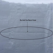
Advisory Archive
Carrot Basin in the southern Madison Range got 2-3 inches of new snow yesterday morning with only a trace falling elsewhere. This morning, under clear skies, mountain temperatures are in the upper single digits with west to north winds averaging 5-15 mph and gusting to 20 mph. Today will be sunny with light winds and mountain temperatures reaching the mid-30s. Tomorrow looks the same, as does Thursday and Friday. Shorts and flip flop sightings are inevitable.


Over the past 24 hours no new snow has fallen. This morning, skies are mostly cloudy and temperatures range from the mid-teens to low 20s F. Winds are blowing 10-25 mph out of the W-NW with a few ridgetop gusts breaking 30 mph. Today, there is the chance of mountain snow showers with 1-2 inches possible. Highs will climb into the mid-20s to low 30s F and winds will continue to blow 15-25 out of the W-NW. A slight chance of mountain snow continues into the evening, but tomorrow looks to be sunny and nice.
Clear skies overnight allowed temperatures to drop into the single digits to low teens F. At 5 a.m. winds are blowing 10-20 mph out of the W-SW. Today, a ridge high pressure will produce clear skies and calm conditions during the morning hours. Highs will warm into the mid-20s to low 30s F and winds will continue to blow 10-20 mph out of the W-SW. The ridge begins to break down this afternoon as a weak storm system approaches the area. Skies will become partly to mostly cloudy by this evening and winds will increase and shift to the W-NW. Light snow is expected during the day tomorrow with 2-4 inches possible by Tuesday.


Since yesterday morning the mountains near Cooke City received 2-4” of snow while the rest of the area remained dry. Temperatures this morning are in the teens to low 20s F. Wind overnight was out of the west-southwest at 20-30 mph with gusts up to 50 mph. Temperatures today will remain in the teens to low 20s F under mostly cloudy skies. Wind will shift to the northwest at 20-30 mph and there is a chance for 1-3” of snow this afternoon and evening.

The mountains around Bozeman and Big Sky received 2-3” of high density snow yesterday, and the mountains near West Yellowstone received 7” of snow. SNOTEL data has not updated since yesterday morning, but I assume Cooke City got 3-7” as well. Temperatures this morning are in the high teens to low 20s F and wind is out of the southwest at 30-40 mph with gusts in the 60s. Today will be mostly cloudy with temperatures in the 20s to low 30s F. Wind will be out of the west-southwest around 30 mph and increase to 40 mph this evening. The southern mountains will get light snowfall today, and a couple inches are expected throughout the advisory area tomorrow.
The mountains have not received any new snow in the last 48 hours. Temperatures this morning are in the high 20s to low 30s F, and winds are out of the southwest at 15-30 mph with gusts exceeding 50 mph in Hyalite and Big Sky. Temperatures will be in the low 30s F this morning and cool to the low 20s F this afternoon. Wind will blow 30-40 mph out the west-southwest with stronger gusts this morning. Expect rain in the valleys this morning turning to snow at all elevations this afternoon. The southern mountains will receive 7-10” of snow and the northern mountains will receive 3-5” by tomorrow morning.
Yesterday, westerly ridgetop winds lessened to 20-30 mph which is where they’ll remain today. This morning mountain temperatures are in the high 20s under mostly cloudy skies. A moist southwest flow will keep skies cloudy as mountain temperatures reach the low 30s. By morning West Yellowstone to Cooke City will have a couple inches of new snow. Tomorrow will be stormy and snowy, although precipitation might begin as rain.
Snowfall in the last 24 hours amounted to 8 inches around Cooke City, 4 inches in Taylor Fork to West Yellowstone, 2-3 inches up Hyalite and 1-2 inches in the Bridger Range and Big Sky. At 5 a.m. skies are cloudy, temperatures are in the high 20s and west winds are gusting 50-60 mph and averaging 20-30 mph. Today the mountains will be windy with another pulse of snow later today dropping 1-2 inches.
Overnight the mountains around Cooke City and West Yellowstone picked up 3-4 inches of new snow while the mountains near Bozeman and Big Sky picked up 1-3 inches. This morning, light snow continues to fall in the mountains across the advisory area. At 5 a.m. Temperatures are in the 20s F and westerly winds are blowing 10-30 mph with gusts over 40 mph. Today, temps will warm into the upper 20s to mid-30s F and winds will remain strong out of the west. Snow will continue through the day with 2-3 inches likely by days end. An additional 1-3 inches is possible tonight into tomorrow.

Over the past 24 hours the Bridger Range picked up 6-8 inches of high density snow. The rest of the advisory area picked up 3-6 inches. At 4 a.m. snow is tapering off and temperatures range from the mid-teens to low 20s F. Winds are blowing 15-30 mph out the W-SW with ridgetop gusts pushing 40 mph. Today, snow will redevelop in the mountains as moisture continues to be ushered into the area on a northwest flow. Winds will shift from the SW to the NW during the day and temperatures will warm into the mid to upper 20s F. Snow accumulations of 1-3 inches can be expected during the day with an additional 2-3 inches falling tonight into tomorrow.