Advisory Archive
There’s no new snow to report this morning, just clear skies under a nearly full moon. Mountain temperatures are in the single digits below zero with ridgetop winds averaging 15 mph and gusting to 30 out of the north to northwest – strong enough to freeze your face off. Temperatures will rise into the low 20s under clear skies as winds remain steady. A strong high pressure system builds today which will block moisture and bring above average temperatures into the weekend. Wah.


It was quite novel shoveling my walk this morning, only if it was just an inch of snow. The mountains fared better with almost two inches falling and three inches reported around West Yellowstone. Currently, mountain temperatures are a few degrees below 0F with light winds out of the north to northeast. Snow flurries will stop this morning and skies will become partly cloudy with temperatures rising into the teens and winds remaining northerly and light. Before the storm ends an inch more could fall around West Yellowstone and Cooke City, but then high pressure builds and chances for snow are zilch through the weekend. A couple inches never felt so deep.
This morning there is no new snow to report and temperatures range from 10-15 F under clear skies. Winds are blowing 10-20 mph out of the W-NW with gusts around Big Sky and Cooke City reaching close to 30 mph. Today will be a transition day as a storm approaches from the northwest. Temperatures will warm into the mid to upper 20s F and skies will become increasingly cloudy. Winds will gradually increase out of the W-NW with gusts over 30 mph expected in upper elevation terrain later in the day. Snow will begin to fall this evening with 2-4 inches likely in the mountains by tomorrow. A sharp drop in temperatures will also arrive this evening. Temps well below zero can be expected tomorrow morning.
This morning temperatures are in the single digits above or below zero F under mostly clear skies. Winds are currently blowing 5-10 mph out of W-NW with a few stronger gusts being recorded around Big Sky. Today, quiet weather will persist over southwest Montana. Temperatures will warm into the upper teens to mid-twenties F and winds will remain light to moderate out of the W-NW. Calm and dry weather will continue over the next 24 hours, but a weak storm system is forecasted to impact the region tomorrow evening into Tuesday morning.
This morning there is no new snow to report and temperatures are a few degrees above or below zero F. Winds are light out of the E-SE and skies are partly cloudy. Today, calm, clear and cold conditions will remain over the area. Highs will only warm into the teens F and there is a slight chance of a mountain flurry during the day. No accumulating snow is expected over the next 24 hours.
Yesterday a few flurries occurred in the mountains near West Yellowstone; otherwise, no snow fell and it was calm and cold. This morning temperatures were in the low single digits F with a few places below zero F. Winds remained surprisingly light this morning blowing westerly at 5-10 mph with gusts of 20 mph in some areas. Today will be mostly cloudy, temperatures should reach the teens F, winds should remain light blowing westerly at 5-10 mph with a few higher gusts, and an inch or two of snow should fall mainly near Big Sky and West Yellowstone.

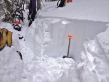
Since yesterday morning the Bridger Range received another 3 inches of snow, the northern Gallatin Range got 5-10 inches, the Madison Range got 1-2 inches, and the mountains near West Yellowstone and Cooke City remained dry. Temperatures this morning were at 5 degrees F in most areas except Cooke City where it was -2 degrees F, and north easterly winds were remarkably calm blowing 1-5 mph gusting to 10 mph. Today should start cloudy with the sun appearing this afternoon. Temperatures should warm to the teens F and winds will remain calm.
Last night 3-4 inches of snow fell in the Bridger Range, northern Gallatin Range and around Cooke City, while two inches are reported around Big Sky and a trace to an inch everywhere else. Winds are averaging 25 mph of the N-NW with gusts of 40-50 mph. Under cloudy skies mountain temperatures are in the mid to upper teens. Today, winds will become moderate under mostly cloudy skies. I expect another 1-2 inches falling this morning with the southern Madison Range and Lionhead area getting mostly missed.
This morning mountain temperatures are 20F with W-NW winds blowing 15-20 mph under clear skies. Today will be mostly sunny and winds will increase with daytime highs reaching the low 30s. A cold front and moist northwest flow are teaming up late tonight bringing snow through tomorrow. By morning, I expect 2-4 inches with much more falling Wednesday. My fingers are crossed that the northwest flow will wring even more snow onto the Bridger Range.


A strong ridge of high pressure is currently dominating the weather pattern. This is creating clear skies, calm winds and cold temperatures. This morning temps range from the single digits above or below zero F and winds are light out of N-NE. Today, temperatures will warm into the 20s F under clear skies and winds will remain light out of the N-NE. High pressure will persist for the next 24 hours, but another storm system is forecasted to impact the area Tuesday night into Wednesday.