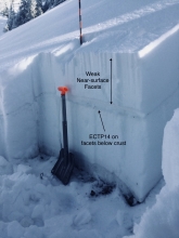
Advisory Archive
In the last 24 hours the northern mountains picked up 7-9” of new snow, Cooke City has 6” and 3” fell around West Yellowstone and the southern Madison Range. Winds are averaging 20 mph from the W-NW with gusts of 50 mph around Big Sky. Mountain temperatures are in the low single digits and will rise into the mid-teens today. Other than a few flurries this morning, today will become sunny and then cloud up tonight with decreasing, 10-20 mph west winds.


At 4 a.m. Santa’s sleigh full of powder is overhead and dropping light snow throughout the advisory area. Temperatures are single digits to low teens F. Wind is west-southwest at 5-15 mph with gusts to 25 mph, and out of the northwest near Cooke City. For Christmas, the mountains will get 2-4” of light powder by evening with another 2-3” possible by tomorrow morning. Temperatures today will reach teens F with westerly wind at 5-15 mph and gusts to 20 mph at ridgelines.
Temperatures are below zero F this morning and will reach the low teens F today. The mountains did not get any snow overnight, and wind has been out of the west-northwest at 20-30 mph since yesterday morning. The cold northwest flow will continue today with clear skies and ridgetop wind speeds at 15-25 mph. The mountains will get a couple inches of new snow early Christmas morning with 3-5” possible through the day.
A cold northwest flow has favored the mountains around Bozeman, Big Sky and Cooke City. Over the past 24 hours, the northern Madison Range (Big Sky) has received 10-14” of low density snow. The mountains around Bozeman and Cooke City picked up 8-10” while the mountains around West Yellowstone picked up 4-6”. At 5 a.m. it’s still snowing lightly around Big Sky, but mostly dry elsewhere. Temps are in the single digits above or below zero and winds are blowing 10-25 mph out of the west-northwest. Today, light snow showers will linger in the northern mountains as the area remains under a northwest flow, but no real accumulation is expected. Temps will remain cold today with highs in the single digits and winds will stay out of the west-northwest at 10-20 mph. Tomorrow looks to be cold and dry.

It’s currently dumping across the advisory area. At 5 a.m. the mountains around Bozeman and Big Sky including the southern Madison Range (Carrot Basin) have picked up 4-6” of low density snow. The mountains around West Yellowstone and Cooke City have received up 2-3”. Temps are in the single digits to low teens F and winds are blowing 10-20 mph out of the west with ridgetop gusts near Hyalite and Big Sky reaching 30 mph. Today, snow will continue with an additional 3-6” falling in the north and 2-4” in the south. Temps will warm into the mid to upper teens F and winds will remain light to moderate out of the west. Snow tapers off this evening and no real accumulation is expected tonight and tomorrow.

Since yesterday morning the mountains around Cooke City and West Yellowstone picked up 8-10” of new snow while he mountains around Bozeman and Big Sky picked up around 6”. At 5 a.m. snow has exited the area and temps are in the single digits above or below zero F under partly cloudy skies. Winds are blowing 10-20 mph out of N-NW. Today, temps will be some of the coldest seen all year with highs only climbing into the single digits to low teens F. Winds will continue to blow 10-20 mph out of the W-NW. Skies will start out mostly clear this morning, but will become increasingly cloudy by this afternoon. Another blast of wintery weather enters the area tonight. By tomorrow morning the northern ranges and Cooke City should see 2-4” of new snow while the West Yellowstone area will see 1-3”.

In the last 24 hours the mountains around Cooke City have 12” of new snow, the southern ranges and West Yellowstone have 5-6”, and Big Sky and the Bridger Range are showing 1-2”. Ridgetop winds are strong out of the southwest with speeds averaging 20-35 mph and gusts of 60 mph. Mountain temperatures are near 20F. After a pre-dawn lull, snowfall will begin this morning and drop 3-4” in all ranges with winds decreasing and snowfall ending later this afternoon.

At 5 a.m. the mountains around Cooke City received 1-2” of new snow. Under cloudy skies winds are W-SW at 25-40 mph in the northern ranges and 10-25 mph in the south with temperatures in the high teens to mid-20s. Today is unsettled with chances of snow increasing throughout the day. By tomorrow morning I expect 2-4” in the north and 6-8” in the south with the storm continuing through Wednesday. Winds will remain westerly and average 20-30 mph as temperatures cool into the teens tonight.
Since yesterday the mountains near Cooke City got 2” of new snow, near West Yellowstone got 1”, and elsewhere got maybe a trace. Temperatures this morning are high 20s F near Bozeman and Big Sky and single digits to teens F near West Yellowstone and Cooke City. Wind is west-southwest at 25-40 mph near Bozeman and Big Sky, and 10-20 mph in the southern mountains. Today, temperatures will be 20s to low 30s F with west-southwest wind at 30-45 mph. Snow today will total 1-2” in most areas with 4-6” near Cooke City by morning.
Since yesterday morning the mountains got 10” of low density snow in Hyalite, 3-5” in the Bridger Range and near Big Sky, and 1-2” elsewhere. Temperatures this morning are single digits to low teens F. Wind is westerly at 15-25 mph with gusts to 40 mph near Bozeman and Big Sky. Today, temperatures will be high teens to low 20s F with wind at 20-30 mph out of the west. Clear skies today will give way to increasing clouds this evening and the mountains could get 1-2” of snow by morning.