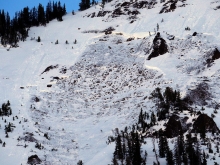
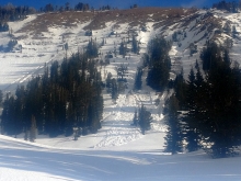
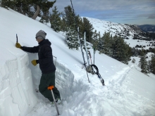
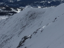
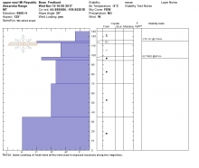
Advisory Archive
Temperatures this morning are in the high 30s to low 40s F. The only new snow is a trace to 1” near Big Sky and West Yellowstone. Wind is west to southwest at 10-25 mph with gusts to 40 mph. Temperatures will reach high 40s F today and up to mid-50s F in the Bridger Range. Wind will be southwest at 10-20 mph, and a welcome cold front late tonight will bring 40-50 mph winds, some rain, and then snow through Monday morning. The mountains will get 3-6” of snow tomorrow with up to 8” possible near West Yellowstone, Cooke City, and Hyalite.

This morning there is no new snow to report and temperatures range from the upper teens to mid-20’s F under mostly clear skies. Winds are blowing 15-25 mph out of the W-SW. Today, temps will warm into the mid to upper 30’s F and winds will continue to blow 15-25 mph out of the W-SW. Skies will remain mostly clear during the morning hours, but will become partly to mostly cloudy by this afternoon. The mountains could see a passing rain or snow shower tonight, but no real accumulation is expected. Tomorrow looks to be mostly dry.

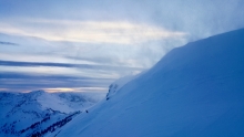
Overnight a fast moving cold front dropped 2-3” of high density snow in the mountains around Bozeman and Big Sky. The snow line ranged between 8-9,000 ft. and rain fell at lower elevations. The mountains around West Yellowstone and Cooke City picked up a trace to 1” of snow above 9,000 ft. At 5 a.m. snow and rain showers have tapered off and temperatures range from the upper 20’s to mid-30’s F. Winds are blowing 20-40 mph out of the west with ridgetop gusts pushing 50 mph. The Cooke City weather station near Lulu Pass recorded a gust of 79 mph this morning. Today, both precipitation and high winds will diminish as a weak ridge of high pressure builds over the region. Temperatures will warm into the mid to upper 30’s F under partly cloudy skies and winds will blow 15-30 mph out of the west. No snow is expected over the next 24 hours and the rest of the weekend looks to be mostly dry.
Snow showers Monday night dropped 4” in the Bridger Range, 1-2” in Hyalite, 3-5” near Big Sky and West Yellowstone, and 7” in Cooke City, with 1-2” more last night. Wind has been west to southwest at 20-30 mph with gusts of 40-50 mph. Temperatures this morning are above freezing up to 9,000’ elevation. There is a chance for light rain this morning, with temperatures in the mid-40s F today and wind out of the west to southwest at 20-30 mph. For Thanksgiving temperatures will reach 50 F, winds of 30-50 mph will precede the passage of a cold front Thursday night, and 2-4” of snow is possible by Friday morning.


There’s been no new snow since Friday night, just wind. Mountain temperatures this morning are in the mid-20s in the north and high teens in the south. Southwest winds picked up overnight and are blowing steady at 35 mph with gusts near 55 mph. As the day progresses skies will become cloudy and winds will decrease and shift northerly. Later today and tonight the mountains will get a little snow and possibly rain in the valleys. By morning I expect 1-2” in the north and 2-4” in the southern mountains. Tuesday looks to be dry and uneventful.
The mountains got 1-2” of snow as the storm ended yesterday. Wind has been out of the west-southwest at 15-30 mph with gusts to 40 mph. Temperatures this morning are single digits to teens F and will rise to high 20s F today. Skies will be partly cloudy with moderate to strong southwest wind at 15-30 mph. There is no new snow expected through the weekend and a chance for a small storm Monday night.

Over the past 24 hours the mountains around West Yellowstone and Cooke City picked up over a foot of new snow. The mountains around Big Sky including the northern Gallatin Range squeezed out 2-3” while the Bridger Range remained mostly dry. At 5 a.m. temperatures range from the upper teens to mid-20’s F and winds are blowing 15-30 mph out of the W-SW. Today, skies will remain mostly cloudy and light snow showers will linger in the mountains south of Bozeman, although no real accumulation is expected. Highs will warm into the upper 20’s to low 30’s and winds will gradually decrease blowing 10-20 out of the W-SW. A weak ridge of high pressure builds over the area tonight and this weekend looks to be mostly dry.
Since 6 a.m. a fast moving storm dropped 4-6” of snow in the mountains around Bozeman and Big Sky and 2-3” in the mountains around West Yellowstone and Cooke City. Currently, snow has tapered off across the advisory area and no additional accumulation is expected. Temps have dropped 5-10° this morning and are currently in the low to mid 20s F. Winds are blowing 15-30 mph out of the west with gusts around Cooke City breaking 40 mph. Winds will decrease throughout the day as a weak ridge of high pressure builds over the area. Conditions will be dry today and tomorrow, but another storm is forecasted to impact the area Thursday and Friday.


At 4 a.m. the Bridge Range has 6-8” of new snow, mountains near Big Sky have 3”, Hyalite has 1”, West Yellowstone 5”, and Cooke City 6”. Temperatures are in the 20s F and wind is out of the southwest at 10-20 mph. Snowfall will taper off this morning with 1-2” more possible. Temperatures will reach the low 30s F this afternoon under mostly sunny skies with westerly wind at 10-15 mph. The rest of the weekend will be dry with wind increasing to 20-30 mph Sunday afternoon. Monday evening into Tuesday looks like the next chance for snow.


In the last 24 hours the mountains around Cooke City recorded 4” of new snow with 1-3” falling everywhere else. At 5 a.m. it is still snowing lightly and ridgetop winds are blowing W-SW at 15-20 mph and gusting to 30 mph with temperatures in the upper teens. Another inch will fall this morning, then skies will clear and temperatures will drop tonight to below 0F. Through Wednesday, skies will be mostly clear and temperatures will fluctuate between zero at night and teens during the day with light westerly winds. A weak storm might bring snow flurries Thursday and Friday.