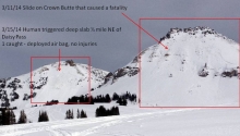
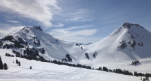
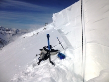
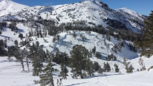
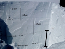
Advisory Archive
A small weather disturbance dropped an inch of new snow in Cooke City last night while everywhere else had clear skies. Mountain temperatures are in the low twenties with ridgetop winds blowing 15-20 mph from the west to southwest. Today will be mostly sunny and temperatures will rise to forty degrees with winds remaining the same. Clouds will form late tonight and snowfall will begin early tomorrow morning and drop 1-2 inches in the southern mountains.

Over the past 24 hours the northern Gallatin Range received 3 inches of new snow. The rest of the advisory area picked up a trace. This morning temperatures are ranging from the single digits to low teens F and winds are blowing 10-20 mph out of the WNW. Today, temps will warm into the 30s F and under mostly clear skies and winds will continue to blow 10-20 from the WNW. Tomorrow looks to be a warmer day with highs in the 40s F and plenty of sunshine.
This morning temperatures are in the upper teens to low 20s F and winds are blowing 15-30 out of the WSW. Today, a weak storm system approaching from the north will bring an increasing chance of snow showers to the mountains around Bozeman, Big Sky and Cooke City. As the storm arrives winds will shift to the NW blowing 15-20 mph and temperatures will warm into the upper 20s to low 30s F. The mountains around Bozeman and Big Sky will likely see 1-3 inches of new snow by tomorrow morning while Cooke City will pick up 3-5 inches.
Overnight the Bridger Range picked up two inches of pixie dust (low density snow) while the rest of the advisory area remained dry. This morning, temperatures are in the single digits and winds are light out of the WNW. Today, a weak northwest flow will make light snow showers possible in the mountains around Bozeman and Big Sky although no real accumulations are expected. Temperatures will warm into the upper teens to low twenties F and winds will remain light out of the WNW. Skies will become partly cloudy by late morning and there’s a good chance from some sunshine this afternoon.
Snowfall started early this morning at Bridger Bowl. By 7 a.m. 6 inches of very low density snow had fallen at the top of the Bridger lift, and Big Sky got a dusting. All other areas were dry. Temperatures this morning had dropped into the single digits and low teens F with light winds blowing 10-15 mph from the WNW at ridgetops. Today will be similar to yesterday but winds will be light. High temperatures will be near 20 F and winds should only blow 5-10 mph. Snowfall in the Bridger Range should end soon with another few inches falling.
This morning temperatures ranged from the high teens to mid 20s F. Winds were averaging 15-25 mph from the SW and gusting to 50 mph. A cold front will move over the area this morning and maintain strong winds. Areas near Bozeman should have the most clouds and may receive a trace of snow. Areas further south should have few clouds and no snow. The combination of cold air and some sun will means temperatures shouldn’t climb past the mid to high 20s F. Winds should stay strong through the day and shift to the W before easing tonight.
Under clear skies mountain temperatures are near 10F with westerly winds blowing 20-30 mph. Yesterday morning another four inches fell in the Bridger and Northern Gallatin Ranges before the sun broke through. Today will start out sunny and become partly cloudy as the day progresses. Temperatures will warm into the mid-thirties with steady ridgetop winds from the west at 20-30 mph.


At 6 a.m. we are at the tail end of a 24 hour storm that clobbered the northern Madison and northern Gallatin Ranges. Storm totals are 28” up Hyalite, 15-18” at Big Sky, 8” in the Bridger Range, 3-5” around West Yellowstone and 7” in Cooke City. Colder temperatures kept the new snow density around 7%. Winds are out of the northwest and averaged 15-20 mph but gusted 40-50 mph during the storm. Snowfall is tapering off and winds have calmed to 10-25 mph. Temperatures are in the mid to low teens and will warm into the low 20s as cloudy skies give way to sun this afternoon.
There may not be a pot of gold in the clouds, but there is a silver lining. That lining is made out of snow which will be falling for much of the day. The storm hasn't done much yet, but with a little luck, the northern mountains and Cooke City area should see 4-6 inches by day's end. The mountains around West Yellowstone will pick up 3-5 inches.
This morning temperatures are in the upper 20s to mid-30s F and winds are blowing 15-25 mph out of the WSW with stronger gusts reaching into the 30s. Today, temperatures will start out warm, but will drop rapidly as the approaching cold front moves over the area. Valley rain and mountain snow will begin by 8-9 a.m., but precipitation will change to all snow by noon. Temperatures will likely drop 10-15 degrees as cold air behind the front settles in. Winds will gradually shift to the NW by this afternoon blowing 15-25 mph. Snow will taper off by midnight and Tuesday looks to be a drier day.
The full moon was bright all night and no new snow has fallen. This morning, mountain temperatures are in the 20s F and winds are blowing 10-20 mph out of the west with gusts in the 30s. Today, skies will start out mostly clear but will cloud up by this afternoon. Temperatures will warm into the mid-30s to low 40s F and winds will gradually increase out of the west blowing 25-35 mph. A fast moving storm will impact southwest Montana starting Monday morning. 3-6 inches of new snow is likely in the mountains by Monday night.