Advisory Archive
Yesterday another 6 inches of snow fell near Cooke City, 2-4 inches near Big Sky, 1-2 inches near Bozeman, and a trace of snow near West Yellowstone. With this snow came very strong winds which were blowing 30 mph gusting 50-60 mph from the W and SW. Gusts on Flanders Mountain in Hyalite Canyon reached 87 mph. This morning winds eased a little but should increase again and blow 15-20 mph from the SW and gust 30-50 mph. Temperatures were teens F this morning and will rise into the mid to upper 20’s F today. Snowfall will return late this morning. 5-7 inches should fall near Cooke City, 3-5 inches near West Yellowstone and Big Sky, and 1-2 inches near Bozeman.

Since yesterday morning 10-12 inches of snow fell near Cooke City, 4-5 inches near West Yellowstone, and 2-3 inches near Big Sky while the mountains near Bozeman remained mostly dry. Every place received strong winds which blew 30-40 mph last night with gusts of 60 mph. This morning winds from the SW were blowing 25 mph gusting to 40 mph and temperatures were in the mid 20’s F. Strong winds will continue today and should increase some this afternoon blowing from the W at 30 mph gusting to 50 mph. Temperatures will rise into the upper 20s F and many places should get about an inch of snow today while Cooke City could get 2-4 inches.
In the last 24 hours one to two inches fell in most mountain areas. The exceptions were Cooke City with over three inches and the Bridger Range with only a trace. Winds are westerly in the Bridger Range, but south to southwest everywhere else. Currently speeds are averaging 20-40 mph with gusts hitting 50-60 mph. Temperatures are in the high teens and will not warm much today. Snowfall throughout the day will measure 2-4 inches by tomorrow morning.
Cooke City picked up an inch of snow last night. Under mostly cloudy skies temperatures are 40F in Bozeman this morning, a whopping 60 degrees warmer than a week ago! Mountain temperatures are in the high teens with ridgetop winds from the west to southwest averaging 20-30 mph and gusting 40-50 mph. Today will have scattered snow showers with 1-3 inches falling as winds continue to blow strong.

Over the past 24 hours the mountains around Cooke City have picked up 3-4 inches of new snow totaling .4 inches of SWE. The mountains around Big Sky and West Yellowstone received around one inch while the mountains around Bozeman have remained mostly dry. This morning, temperatures are in the teens F and winds are blowing 15-25 mph from the west with ridgetop gusts in the thirties around Big Sky. Today, a weak ridge of high pressure will build over the area allowing temperatures to warm into the 20s F under partly cloudy skies. Winds will remain light to moderate out of the west. This break in the weather will be short-lived as another storm system is forecasted to impact our area tomorrow into Wednesday.
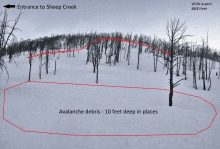
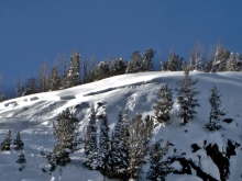
Over the past 24 hours 4-6 inches of low density snow has fallen in most mountain locations with the exception of Cooke City which has received closer to 10 inches. The two day storm totals are impressive. The mountains around Big Sky and West Yellowstone have received well over a foot low density snow totaling .7-.8 inches of SWE. The mountains around Cooke City have also received well over a foot of snow totaling 1” of SWE. The Bridger Range and Northern Gallatin Range have received 6-8 inches totaling .3-.5 inches of SWE.
Currently, temperatures are in the teens F with the exception of the Bridger Range where temps are in the single digits F. Winds are strongest near Big Sky including the northern Gallatin Range where they are blowing 20-40 mph out of the west-southwest. Winds are blowing 10-25 mph in all other areas. Today, snow will end by late morning and skies will begin to clear by this afternoon. Temperatures will warm into the twenties F and winds will continue to blow 15-25 mph from the west-southwest with localized gusts in the thirties. There will be a break in the weather tonight and tomorrow with more snow expected on Tuesday.


This morning NRCS Snotel sites are down and we are unable to receive accurate snowfall amounts for many areas. Fortunately, the ski area weather sites are still up and running. Overnight, the Timber weather station at the Yellowstone Club has recorded nearly a foot of new snow. Bridger Bowl has recorded 2-3 inches of new snow over the past 24 hours.
Currently, temperatures are around ten degree above zero F in most mountain locations. Winds are blowing 15-30 mph out of the west-southwest with the exception of the Bridger Range and mountains around Cooke City where winds are blowing 5-15 mph. Today, temperatures will warm into the upper teens to low twenties F and winds will continue to blow 15-30 out of the west-southwest. Snow will continue through much of the day with an additional 3-5 inches possible in the mountains around Big Sky, West Yellowstone and Cooke City. The Bridger Range will likely pick up 2-4 inches.
In many places compared to yesterday it is 30 degrees warmer this morning with mountain temperatures in the single digits F. Good thing it warmed because winds increased to 10-20 mph with gusts of 25 mph from the SW. This morning 2-3 inches new snow fell near Cooke City and West Yellowstone. Other areas were dry. Today temperatures should warm into the low teens F. Winds will shift to the W and decrease a little. Snow will fall in most areas. The southern areas should get 4-5 inches of snow while the northern areas should get 1-3 inches. Snow will end tonight but will return tomorrow morning.

This morning temperatures ranged from -25 F to -13 F. The good news is that mountain temperatures were averaging 2.4 degrees warmer than yesterday morning. Oh yeah! However, an inversion this morning means that some valley locations have temperatures near -40 F. Winds were blowing 5-10 mph from the SW. Today temperatures may rise slightly above 0 F and winds will increase to 5-15 mph from the SW. Near Cooke City and West Yellowstone, some clouds should appear late this afternoon and bring about an inch of new snow tomorrow morning.
The weather can be summed up in one word: COLD. It was cold yesterday, will be cold today and cold again tomorrow. Temperatures are measuring – 20F in most mountain locations with the Bridger Ridge coming in at -27F. Ridgetop winds averaged 20 mph with gusts to 30 mph from the east in the Bridger Range yesterday and 10-20 mph from variable directions everywhere else. No snowfall is expected through the week, just frigid temperatures and light winds. Aspiring to be a polar explorer? Well, today’s your day to train.