Advisory Archive
Yesterday, the Bridger Range picked up 8 inches of new snow. The northern Gallatin Range and mountains near Big Sky picked up 5-6 inches and the mountains near West Yellowstone and Cooke City picked up 3-5 inches. Currently, temperatures are in the single digits and winds are blowing 5-20 mph out the WNW. Today, our region will remain under a dry northwest flow which will keep temperatures on the cool side. Highs today will warm into the upper teens to low twenties F under partly cloudy skies and winds will stay light to moderate out of the WNW. No new snow is expected today or tonight.


The first waves of moisture from a pacific storm are starting to impact our area. As of 6 am 8 inches of snow has accumulated in the mountains near Big Sky. The mountains around West Yellowstone and Cooke City have picked up 2-4 inches while the mountains near Bozeman have picked up a trace to one inch. Snow will continue through the day with an additional 5-7 inches likely in the mountains near Big Sky and West Yellowstone. The mountains near Bozeman and Cooke City will pick up 4-6 inches.
Currently, temperatures are in the teens F and winds are blowing 10-25 mph out of the WSW with ridgetop gusts reaching into the 30s. Today, high temperatures will climb into the upper teens to mid-twenties and winds will continue to blow 15-25 out of the west. There will likely be a spike in wind speed as the front passes later this morning. Snow will gradually taper off tonight.

It’s snowing this morning. As of 6 a.m. the mountains near Bozeman and Big Sky received 1-3 inches of snow and all other areas received a trace. Temperatures were in the single digits and low teens F. Ridgetop winds at Bridger Bowl and Hyalite Canyon were blowing 20-35 mph from the W. Most other areas this morning had winds blowing 10-25 mph from the W. Snow will end this morning but return late afternoon or early evening.
Today will remain cold with temperatures struggling to climb out of the teens F and winds may increase a bit more this afternoon with the next round of snow. Snowfall today and tonight should bring 2-4 inches of new snow by tomorrow morning although tonight’s snow should favor the mountains near Cooke City and West Yellowstone.
Since yesterday morning Hyalite Canyon received 3-5 inches of snow while all other areas received about 2 inches. Temperatures this morning were in the single digits and low teens F. Northerly winds were averaging 5 mph and gusting to 10 mph. Dry air will move over the area this afternoon and allow some sunshine. Temperatures will warm into the high teens F today and winds will remain light. A trace of snow may fall early tomorrow morning. Winds will shift to the W and increase Friday night.

Since yesterday morning a trace to one inch of snow fell in the southern mountains. Under clear to partly cloudy skies temperatures are in the teens and winds are eerily calm. Clouds will increase today with light northwest winds and temperatures in the low twenties. Scattered snow showers will drop 1-2 inches tonight.
Since early yesterday morning there’s no new snow to report. Southerly winds are light at 10-20 mph except in Hyalite where they are blowing 25-40 mph. Under mostly cloudy skies temperatures are in the teens, but winds and temperatures are not expected to fluctuate much today. Moisture streaming in from the southwest will only drop a trace to one inch of new snow by morning, but hopefully a little more tomorrow.
Over the past 24 hours the Bridger Range has received ten inches of new snow. The northern Gallatin Range has picked up 6-8 inches and the mountains around Big Sky squeezed out 3-4 inches. The mountains near West Yellowstone and Cooke City picked up 1-2 inches. Currently, it’s still snowing lightly in the northern mountains and temperatures are in the single digits to low teens F. Winds are blowing out of the WNW at 5-15 mph. Today, snow will end by late morning and temperatures will warm into the 20s under partly to mostly cloudy skies. Winds will stay light and should shift to the WSW by this afternoon. No major accumulations are expected today into tomorrow.
Overnight the mountains around Big Sky picked up 5-7 inches of new snow and it’s still snowing. The Bridger Range, southern Madison Range and mountains around Cooke City picked up 3-5 inches, while the mountains around West Yellowstone picked up around 1 inch. Snow will continue through the day with additional 4-6 inches likely in the mountains near Bozeman and Big Sky. The mountains around West Yellowstone and Cooke City will see additional accumulations of 3-5 inches.
Currently, temperatures are in the high teens to low twenties F and winds are blowing 20-30 out the WNW. Temps will not warm much as a cold front moves over the area. Highs today will stay in the twenties F and winds will remain out of the WNW blowing 15-25 mph. Colder air will remain over the area the next few days.
No snow fell since yesterday. This morning temperatures were mostly in the low 20s F. Winds were blowing 15 mph from the W with gusts of 25 mph. A short lived ridge of high pressure will bring another day of mostly sunny skies and warm temperatures. Temperatures will rise into the 30s F with no change in the winds. Clouds will return tonight. Snow will start falling early tomorrow morning and continue through the day.

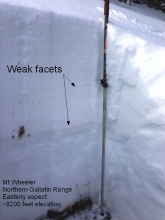
Since yesterday the northern Gallatin Range received 5 inches of new snow and probably more up high in Hyalite Canyon. The Bridger Range, northern Madison Range and mountains near Cooke City received 2-3 inches. The mountains closer to West Yellowstone received a trace to one inch. This morning temperatures were in the low teens F and winds were averaging 10-15 mph from the W and NW with gusts of 20-25 mph. Today will be partly sunny with temperatures around 20 degrees F. Winds will blow 10 mph and gust to 25 mph from the W and NW. Saturday should be sunny with more snow coming Sunday.