Advisory Archive
This morning ridgetop temperatures were in the low 20s F. Lower elevations had temperatures in the high 20s F. Winds were blowing westerly at 10-15 mph in most areas. Today will be cooler than yesterday, and temperatures will be in the high 20s F to low 30s F with some sunshine and clouds. Winds will continue at 10-15 mph generally from the W. There is a chance for snow today and a better chance tonight. By tomorrow morning, 1-3 inches will accumulate in most areas. Snowfall will continue tomorrow.

This morning mountain temperatures were near freezing at ridgetops and near 40 degrees F at lower elevations. Winds were blowing 15-20 mph from the WSW and gusting to 35 mph. Today’s exact temperatures will be a factor of cold air pushing south at 10K feet, warm air in places at 5K feet, and a mix of sun and clouds. Overall high temperatures will be in the 40s F. There will be a small chance for some snow or rain. Fortunately cold air will arrive tomorrow followed by snow and even colder air on Sunday.
Warm weather is the story today. Temperatures this morning were a few degrees either side of freezing and winds were blowing 10-20 mph from the W and SW. Skies today will have some clouds which hopefully will keep the sun at bay. Mountain temperatures will be in the 40s F with winds continuing at 10-20 mph. Tomorrow a small disturbance and slightly colder temperatures may produce a few snowflakes. A better chance for colder temperatures and snowfall will arrive on Sunday.
Yesterday morning one inch of snow fell in the southern Madison Range, Lionhead and Cooke City areas. Temperatures warmed to near 32F at 9,000 feet and have only cooled into the mid-twenties last night. Winds have increased out of the west and are blowing 20-35 mph. Partly cloudy skies will become mostly cloudy by late this afternoon and mountain temperatures will rise into the upper thirties today. No new snow is expected; just spring-like warmth, some sun and a few muddy trailheads at lower elevations.
This morning there is no new snow to report. Mountain temperatures are in the low teens under partly cloudy skies. West winds have decreased from 20-40 mph to 15-20 mph. Clouds will build throughout the day as temperatures rise into the upper 20s and winds remain the same. The southern mountains may get a few flurries later today, but accumulations should be less than an inch.

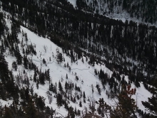
Over the past 24 hours most areas picked up 1-2 inches of new snow with the exception the Bridger Range which has remained dry. This morning, temperatures are in the upper teens to mid-twenties F and winds are blowing 15-30 mph out of the WNW with gusts near Big Sky reaching into the 40s. Today, highs will climb into the upper 20s to low 30s and winds will continue to blow 15-30 mph out of the WNW. A weak weather system will move across the region producing valley rain and light mountain snow. Most areas will pick up and additional 1-2 inches with the excepting of Cooke City which will likely see 3-5 inches by tomorrow morning.
At 4 a.m. mountain temperatures are ranging from the mid-teens to low twenties F and winds are blowing 10-20 mph out of the WNW. Today, clear skies and plenty of sunshine will allow temperatures to warm into the upper 20s to low 30s F. Winds will remain light this morning but will gradually increase through the day. Clouds will also increase this afternoon as the existing ridge of high pressure begins to break down. A weak weather disturbance will push into southwest Montana late tonight creating a chance of valley rain and mountain snow by tomorrow morning.

Over the past 24 hours the mountains around West Yellowstone and Cooke City including the southern Madison Range picked up 2-3 inches of snow. The mountains around Big Sky picked up around one inch while the Bridger Range remained dry. Currently, temperatures are in the mid-teens to low twenties F and winds are blowing 5-15 mph out of the NW. Today, temperatures will warm into the upper twenties to low thirties F under clear skies and winds will stay light out the NW. Beautiful weather is on the books for the next 24 hours.

Overnight the mountains near Cooke City and West Yellowstone received an inch of new snow. A few other areas got a trace. This morning temperatures were near 20 degrees F. Winds were blowing 5-10 mph from the S with gusts of 15 mph – surprisingly calm for SW Montana. Today mostly cloudy skies will keep temperatures from rising above freezing and winds will remain calm. The mountains near Big Sky and West Yellowstone could get an inch of snow while Cooke City could get a few inches. This weekend should have calm winds and sunny skies with a chance of snow for Monday.
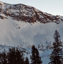
Since yesterday the mountains near West Yellowstone received 8 inches of dense snow, the mountains near Cooke City and the Southern Madison Range received 5-6 inches, the Bridger Range received 4 inches of very dense snow, the mountains near Big Sky received 2-3 inches, and the Northern Gallatin Range received 1 inch. SW winds increased yesterday and were averaging 10-20 mph this morning with gusts of 35 mph. Temperatures were in the high teen F.
Today the northern half of the advisory area will see more sun than the southern half. Depending on the amount of sunshine high temperatures will climb into mid 20s to low 30s F and steady SW winds will continue. More snow will come tonight and deposit 2 inches of new snow at the southern end of the advisory area.
