Advisory Archive

There is no new snow this morning. Winds ramped up overnight to 20-35 mph with gusts of 35-60 mph out of the southwest and west. Temperatures are in the teens and 20s F. High temperatures today will be in the 20s and 30s F under partly to mostly cloudy skies. Strong winds will continue out of the southwest and west. Snowfall is expected to return tomorrow.


There is no new snow to report. Winds are out of the south and west at 15-25 mph, gusting 30-40 mph. Temperatures are in the teens and 20s F. Today will be mostly sunny, with high temperatures in the 20s F. Moderate to strong winds will continue out of the south and west. A few flakes of snow may fall tonight, but the next chance for significant accumulation is on Sunday.


In the last 24 hours most mountains received a trace to 1” of snow with 2” falling in Cooke City. Wind is westerly at 15 mph and gusting to 35 mph. Temperatures are in the teens in the northern mountains and single digits down south. Today will be sunny with temperatures reaching the high 20s F as high pressure builds. Westerly wind will increase later this afternoon and gust 40+ mph tonight under clear skies.


In the last 24 hours, the Bridger Range received 4-7” of new snow, with 1-3” elsewhere. Mountain temperatures range from the single digits to teens F above freezing near Bozeman and Big Sky to the negative single digits F near West Yellowstone and Cooke City. Winds are 15-25 mph from the west to southwest and 5-15 mph in Cooke City. Today, high temperatures will be in the 20s F near Bozeman and Big Sky and in the positive teens F farther south. Winds will be 15-25 mph from the west to southwest, and the mountains will get a trace to 1” of snow.


This morning, temperatures range from the minus teens F in Cooke City and West Yellowstone to a balmy 0 F in the Bridger Range. Winds are 15-25 mph from the west to southwest, and there is no new snow. High temperatures today will be in the positive single digits F in the southern advisory area to the teens F in the north. Winds will blow 15-25 mph from the west to southwest and there will be a trace to 1” of new snow by morning.


This morning there is no new snow. Temperatures are 10-20 degrees below zero F. Wind is out of the northwest to west at 10-25 mph with gusts of 20-35 mph. Today, under mostly sunny skies, temperatures will reach single digits above zero F with west-northwest wind at 15-25 mph. The next chance for snow is tomorrow through Wednesday.


This morning, there is no new snow, temperatures are negative teens to negative 20s F, and wind is 0-10 mph with gusts of 15-20 mph out of the east-northeast. Today will be partly cloudy with temperatures 5-15 degrees below zero F and northerly wind at 5-15 mph. A few snowflakes may fall the next couple days, but the next chance for significant snow is Tuesday.

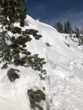
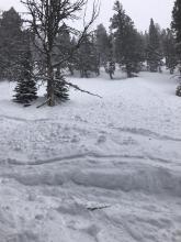
In the last 24 hours (6 a.m.) the Bridger Range has gotten 19”; Hyalite and Big Sky, 12”; Taylor Fork, West Yellowstone and Cooke City, 5-7”. Wind is blowing east at 33-47 mph in the Bridger Range and west to north at 10 mph with gusts of 35 mph everywhere else. Snowfall will end this morning after dropping a couple more inches and winds will lessen out of the west to north to 10-20 mph. Tonight temperatures will drop into the negative teens.


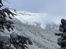
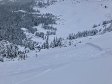
At 6 am there are 10-12” of new snow (0.8-1.3” Snow Water Equivalent) around Bozeman and Big Sky, and 5-6” (0.4-0.5” SWE) around West Yellowstone and Cooke City. Winds are 15 mph gusting 30 mph out of the southwest and west. Temperatures are in the high 20s in the north and teens in the south. It is currently snowing heavily in the northern mountains. Expect 12-18” more snow by tomorrow morning around Bozeman and Big Sky, much of that falling during the day today. West Yellowstone and Cooke City will get 6-12” today and tonight. Moderate southwest and west winds will continue.


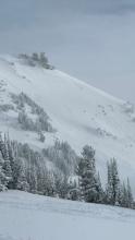
This morning, there are 3-5” of new snow around Bozeman, Big Sky, and Cooke City, with 1-2” near West Yellowstone. Winds are 15-20 mph out of the north and west with gusts of 25-35 mph. Temperatures are in the teens and 20s F. High temperatures today will be in high teens to low 30s F. Moderate winds with strong gusts will continue and may even pick up a bit this afternoon, shifting to the west and southwest. Snowfall will begin this morning in northern areas with 4-6” expected by nightfall. Snowfall will begin later this afternoon near West Yellowstone. By tomorrow morning, expect 6-10” of new snow near West Yellowstone and 10-20” near Bozeman, Big Sky, and Cooke City. Heavy snowfall will continue tomorrow.

