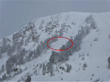
Advisory Archive
Since yesterday morning the Bridger Range got 2-3” of low density snow, Hyalite and Big Sky got 1”, and elsewhere got none. This morning temperatures are single digits to low teens F, and wind is westerly at 15-25 mph with gusts to 30-40 mph. Today temperatures will reach low to mid-teens F and wind will be westerly at 15-30 mph. The next few days are mostly clear with moderate to strong wind, then a chance for snow at the end of the week.


Since yesterday the mountains near Bozeman got 2-4” of new snow, near Big Sky got an inch, and elsewhere did not get any. Overnight, wind was westerly at 10-20 mph with gusts to 25 mph. This morning temperatures are single digits to low teens F. Today temperatures will reach mid-teens F or less. Wind will be westerly at 15-25 mph in the northern mountains and 5-15 mph in the southern mountains. Today there is a chance for 2-3” of snow before skies clear for the next few days.


There is only a trace to an inch of new snow this morning. Winds are westerly at 5-15 mph. Temperatures are in the single digits to high teens F. Several pulses of light snowfall today and tonight will drop an inch or 2 around West Yellowstone and Cooke City, and 2-4” near Bozeman and Big Sky. Temperatures will rise to the high teens to low-20s F. Winds will be 10-20 mph out of the west and northwest under cloudy skies.

This morning, there are 1-3” of new snow around Bozeman and Big Sky, 4-6” around West Yellowstone, and 5” near Cooke City. Winds are west at 15-25 mph, gusting up to 45 mph. Temperatures are in the high teens to low twenties. Showery snowfall will continue today and through tonight. Expect 1-2” across most of the advisory area by tomorrow morning, with 4-6” near Cooke City. Winds today will be westerly at 15-30 mph with strong gusts. High temperatures will be mid-20s to low-30s F under cloudy skies.

At 6 a.m. there is 1-2” of new snow in the north and 3-4” in the south. West to southwest wind is averaging 15-20 mph and gusting to 40 mph and temperatures are in the high teens to low twenties. Snow will continue this morning with another round tonight. By tomorrow morning the northern mountains will have 3-6” and 6-8” in the south. Today, wind will remain westerly at 20-30 mph and temperatures will rise into the low 20s and drop to the low teens tonight.


Under cloudy skies, temperatures are in the teens and winds are blowing west to southwest at 15-20 mph with gusts of 30 mph. The next few days will have unsettled weather. Temperatures will rise into the 20s and wind will increase from the southwest at 20-30 mph. Today, scattered snow showers will drop 2-4”. More snow is expected tomorrow which will favor the southern ranges.
At 5 a.m. there is no new snow to report. Mountain temperatures are in the teens and west winds are averaging 10-20 mph with gusts of 30 mph. Today will be mostly sunny. Temperatures will be in the high 20s and winds will blow at 5-15 mph from the west.
The mountains got 4-6” of snow before the storm ended mid-day yesterday. Yesterday afternoon wind was west-northwest at 20-30 mph with gust to 45 mph. This morning wind is westerly at 5-15 mph and temperatures are single digits to teens F. Today will be partly cloudy with temperatures in the mid-teens to low 20s F and west-northwest wind at 10-20 mph. The next chance for significant snow is Wednesday.


This morning it is snowing across the advisory area, and snow will continue through this afternoon. At 6 a.m. the mountains have 6-10” of new snow near West Yellowstone, 8” near Cooke City, 4” near Big Sky and 1-2” near Bozeman. Wind is westerly at 15-25 mph with gusts in the 40s. Temperatures are 20s to low 30s F. Today, temperatures will drop to the low 20s and teens F, wind will be west to northwest at 20-30 mph and the mountains will get 5-8” of snow by tonight.

There is no new snow this morning. Temperatures are mid-20s to low 30s F and winds are 20-30 mph out of the south and west with gusts as high as 50 mph. High temperatures today will be in the low to mid 30s F. Winds will remain moderate to strong out of the southwest. Snowfall will begin this afternoon with 8-10 inches by tomorrow morning near West Yellowstone and Cooke City and 1 to 3 inches near Bozeman and Big Sky.