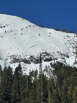
Good morning. This is Dave Zinn with the Gallatin National Forest Avalanche Forecast on Tuesday, March 19th at 6:45 a.m. Today’s forecast is sponsored by Klim and the Yellowstone Club Community Foundation. This forecast does not apply to operating ski areas.
Mountain temperatures are in the upper 20s to mid-30s F this morning, with 5-15 mph winds from the west to the north. There is no new snow. Today, under sunny skies, temperatures will climb to the upper 40s to mid-50s F, a few degrees warmer than yesterday. Winds will blow 5-10 mph from the southwest to northwest. We expect cooler temperatures and snow to return during the second half of the week.
All Regions
Wet snow avalanches will increase in size and volume as temperatures rise. These will most likely release as loose snow avalanches, but larger, wet slab avalanches are possible. Backcountry travelers or smaller wet snow slides may trigger large, dry snow avalanches breaking on deeply buried persistent weak layers. The danger of both will rise throughout the day as melt-freeze crusts break down and the surface snow becomes wet.
Temperatures barely dipped below freezing last night, and wet snow concerns are increasing. The snow surface and avalanche conditions will evolve quickly and will vary significantly by aspect. At Beehive Basin yesterday, we noted these differences and that backcountry travelers must anticipate these daily changes to stay safe (video). Local ski patrols mitigated the risk of wet snow avalanches with terrain closures. Look at the photos and read about a small avalanche on Mt. Blackmore, a small, wet snow avalanche that triggered a dry snow avalanche on Woody Ridge (photo and details), and slides on Crown Butte and Scotch Bonnet that gained significant volume for examples of wet snow activity (Crown Butte wet snow avalanche, video). Think like the local ski patrols and “close” terrain by moving to cooler aspects or heading home before surface crusts break down and more than the top few inches of the snowpack get wet. Ensure a safe exit through lower elevations where temperatures are likely warmer.
Large, dry slab avalanches breaking deep and wide on persistent weak layers remain a scary possibility. The recent avalanche on Woody Ridge outlined above, a slide in the Taylor Fork that piled debris high in the runout zone (Taylor Fork photo and details) and an avalanche on the Lawnmower just outside the advisory area demonstrate the potential. Select smaller slopes with fewer consequences and follow safe travel protocols if you choose to enter avalanche terrain (Cooke City video). Like the rest of the advisory area, the snowpack structure is weak in the Bridger Range, but we are unaware of any recent deep slab avalanche activity. Thus, wet snow avalanches are the dominant concern in the Bridger Range.
The avalanche danger will start the day rated as MODERATE. The danger of wet snow avalanches will quickly increase to CONSIDERABLE, with slides becoming likely as the day warms.
If you venture out, please fill an observation form. It does not need to be technical. Did you see any avalanches? How much snow is on the ground? Was the wind moving snow? Simple observations are incredibly valuable. You can also contact us via email (mtavalanche@gmail.com), phone (406-587-6984), or Instagram (#gnfacobs).
Upcoming Avalanche Education and Events
Our education calendar is full of awareness lectures and field courses. Check it out: Events and Education Calendar.
Loss in the Outdoors is a support group for those affected by loss and grief related to outdoor pursuits. Check out the link for more information.
The Colorado Avalanche Information Center, the Avalanche Research Program at Simon Fraser University and the U.S. National Science Foundation National Center for Atmospheric Research are conducting research to examine how backcountry recreationists, including skiers, mountain snowmobilers, snowshoers and ice climbers, interpret avalanche forecast information. They aim to better understand how useful different kinds of avalanche forecast information are for trip planning. To participate, take the Colorado Avalanche Information Center survey.


