Advisory Archive
Since yesterday a few places near Cooke City and West Yellowstone received a trace of new snow. This morning ridgetop temperatures were in the mid teens F and W/SW winds were blowing 20-30 mph with gusts up to 60 mph. Today will be cold, windy, and snowy. Temperatures may climb a few degrees this morning before cold air moves into the area. Winds will blow mostly from the W at 25-40 mph. Snow will start falling early this morning. By tomorrow morning 4-6 inches will accumulate near Cooke City and West Yellowstone. Further north near Bozeman and Big Sky, 2-4 inches will accumulate.


Lingering snowfall yesterday produced 2-3 inches in most areas. Last night winds increased blowing 20 mph and gusting to 40 mph from the W. This morning winds calmed and were blowing 10-15 mph with gusts of 25 mph. Temperatures were in the single digits to low teens F. A short-lived, upper level ridge will bring dry weather today with a mix of sun and clouds and temperatures near 20 degrees F. Winds will remain about the same speed but shift to the SW as a trough of low pressure approaches tonight. Snowfall will begin tomorrow morning.


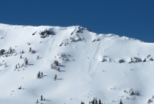
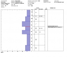
In the last 24 hours the heaviest snowfall occurred in the Bridger Range and the mountains near Cooke City. Yesterday’s snow was wet and heavy while snow that fell late last night had a much lower density because temperatures dropped into the low teens and single digits F. The exact amount of snow is hard to gauge, but the snow water equivalent (SWE) is measured exactly and tells how much weight was added to the snowpack:
- Near Cooke City 1 inch of SWE (5-10” of snow)
- In the Bridger Range 0.5 - 0.9 inches of SWE (3-5” of snow)
- Near Big Sky, Hyalite, and West Yellowstone 0.4 to 0.6 inches of SWE (2-4” of snow)
- Near the Taylor Fork 0.2 inches of SWE (1-2” of snow)
Further complicating snowfall totals is yesterday’s extreme winds which averaged 50 mph from the W with gusts of 60-90 mph. This morning winds were blowing 15-20 mph from the WNW with gusts of 40 mph. Today will be mostly cloudy with an additional 2-4 inches of snow falling. Temperatures will warm into the high teens F.

During the last 24 hours snow fell, winds blew and temperatures warmed. Since yesterday morning the mountains got 4 to 10 inches of new snow with varying densities. The Bridger Range has gotten 6” of 20% density snow (1.2” Snow Water Equivalency or SWE); the northern Gallatins, Big Sky area and West Yellowstone received about 5” of new (.7-.9” SWE) and Cooke City has about 10 inches (1.4” SWE). Higher elevations were colder than the measuring stations. Colder air makes lower density powder with the same water equivalency, so expect substantially more snow the higher you go. Winds are blowing out of the west at 30-60 mph with mountain temperatures in the mid to high 20s. The storm will continue today and drop another 6-10 inches in the mountains (.6-.8” SWE) with strong winds and falling temperatures.
At 6 a.m. seven to nine inches of new snow has fallen throughout southwest Montana. A moist Pacific storm is driving through on a northwest flow. Mountain temperatures are in the teens and ridgetop winds are blowing west to northwest at 25-35 mph. The storm is expected to pick up later this morning and last through Wednesday. Today winds will pick up to 30-40 mph and more snow will fall. By morning I expect 10-12 inches in the mountains.
Over the past 24 hours quiet weather has been in place over southwest Montana. This pattern should continue through much of today. Currently, mountain temperatures are ranging from the single digits to low teens and winds are blowing out of the WNW at 15-25 mph. Today, temperatures will climb into the twenties and winds will gradually increase out of the WNW blowing 25-35 mph. Skies will remain mostly clear through the morning, but an approaching front will produce increasing clouds by this evening. A warming trend will allow temperatures to rise to above seasonal averages by tomorrow.
Over the past 24 hours 3-5 inches of snow has fallen over the advisory area with the exception of the Bridger Range which picked up 6-7 inches. Mountain temperatures are currently in the single digits and winds are blowing 5-15 mph out of the WNW. Today, an unsettled weather pattern will continue with an additional 1-2 inches possible in the mountains. Temperatures will warm into the teens and winds will increase to 10-20 mph out of the WNW. Conditions will gradually dry out by tomorrow but another storm system is scheduled to arrive on Tuesday.
Since yesterday morning a trace to one inch of snow has fallen over the mountains of our advisory area. Currently, mountain temperatures are in the teens and winds are blowing out of the WSW at 10-20 mph. Today, temperatures will warm into the 20s F and winds will shift to the WNW blowing 15-25 mph. An approaching cold front will produce an increased chance of snow showers by this afternoon. 3-5 inches will likely accumulate in the mountains by tomorrow morning.