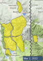
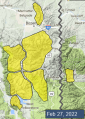
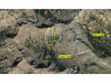
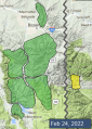
Advisory Archive
This morning temperatures are in the mid 20s F in the mountains around West Yellowstone and Cooke City and in the low 30s F near Bozeman and Big Sky. Winds are 15-20 mph from the west to southwest and there is 1-3” of new snow in the mountains near Cooke City and Big Sky. Today, high temperatures will be in the mid 30s to mid 40s F with 10-15 mph west to southwest winds. Cooke City may get a trace of new snow by morning.


This morning temperatures range from 20 degrees F to the mid 30s F. Strong winds are blowing 15-35 mph from the west to southwest and the mountains near Big Sky and Cooke City received 1-2” of new snow. Today, temperatures will be in the low 30s F to mid 40s F with snow levels between 7,000-8,000’ elevation. Winds will be 20-30 mph from the southwest and the mountains will receive a trace to 2” of snow by tomorrow morning.


This morning, there is no new snow, temperatures are teens to low 30s F, and wind is southwest-west at 10-25 mph with gusts of 25-60 mph. Today, temperatures will reach high 20s to high 30s F with low 40s F in the Bridger Range. Wind will become stronger out of the west-southwest with average speeds of 15-30 mph and gusts of 30-50 mph. Skies will be mostly cloudy today with 1-3” of snow possible by mid-morning tomorrow.
This morning, there is no new snow, temperatures range from single digits to mid-20s F, and wind has been westerly at 15-25 mph with gusts of 25-40 mph. Today, temperatures will reach high 20s to low 30s F, and wind will be west-southwest at 10-20 mph with gusts of 25-30 mph. There’s a chance a few snowflakes will fall this afternoon near Big Sky and West Yellowstone. Tomorrow night a few inches of snow are possible throughout the forecast area.


There is no new snow this morning. Temperatures are in the single digits above and below 0 F. Winds are generally 15 mph out of the west/northwest with gusts of 20-30 mph, except for in the Bridger Range where they are blowing 30 mph with gusts of 45 mph. These winds will continue today under mostly sunny skies. High temperatures will be in the 20s and 30s F. The next chance for a little bit of snowfall is tomorrow night.


A light dusting of snow fell yesterday with less than an inch accumulating. Temperatures this morning are in the single digits below 0 F. Winds are remarkably calm (<10 mph at ridgelines) except for in the Bridger Range where they are blowing 20 mph and gusting 30 mph out of the west. Winds will increase across the rest of the area today up to 15-25 mph out of the west and southwest. High temperatures will be in the single digits and teens F under mostly sunny skies. No new snow is expected through the weekend.

This morning there is no new snow, mountain temperatures are around -5 F and wind is west at 10-20 mph with gusts of 35 mph. Today will be mostly cloudy, wind speed will continue to be light to moderate out of the west and temperatures will rise into the high single digits. The mountains will get a few flurries today with the southern ranges near West Yellowstone and Cooke City getting 1-2” of snow by morning.


Frigid temperatures continue with readings of -23F at 7300’ and -4F at 9000’. This 15-20 degree temperature inversion should last today under sunny skies. Easterly wind has calmed overnight to 5-15 mph. Today will remain cold, the wind will be light and tonight will be chilly, with lows of -10F. By tomorrow the polar weather should be gone.
Temperatures this morning range from -12 to -25 degrees F with 5-10 mph winds from the east to northeast and except in the Bridger Range where they are gusting to 60 mph. Lone Peak received 2” of new snow. Today, strong winds will continue to blow 25 mph from the east in the Bridger Range and 5-10 mph elsewhere. Temperatures will be in the negative to positive single digits F. Light flurries will bring a trace of new snow.

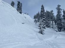
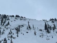
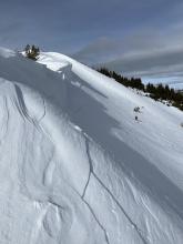
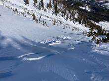
It is cold this morning with temperatures in the single digits above and below zero F and 5-10 mph winds from the west except in the Bridger Range where they turned east. In the last 24 hours, the Bridger Range received 13” of snow with 5-9” near Cooke City, Big Sky and south of Bozeman and 1-4” from the Taylor Fork to Lionhead areas. Today, high temperatures will be in the single digits F before plummeting this evening and a frigid east wind will settle in for the first half of the week. Flurries today will deliver up to an inch of new snow.