Advisory Archive
Since yesterday morning the mountains picked up 1-3” of new snow. Additional accumulation is unlikely today as cold-dry air moves over the region. At 5 a.m. temperatures are 10-15 below zero F in the Bridger Range and single digits above zero F elsewhere. Winds are blowing 10-30 mph out of the west-northwest. Today, highs will barely warm into the teens F and winds will remain light to moderate out of the west-northwest. No real snow accumulation is expected over the next 24 hours.


Over the past 24 hours the mountains picked up 4-7” of new snow. At 5 a.m. snow has tapered off and skies are beginning to clear. Temps are in the single digits F and winds are blowing 15-35 mph out of the west-northwest. Today, skies remain partly to mostly cloudy and temps warm into the teens. Winds will continue to blow 15-30 mph out of the west-northwest. The mountains could see 1-2” of snow tonight, but snowmageddon appears to be letting up for the next few days.

The snowfall continues unabated. Since yesterday morning the southern mountains, including Cooke City, received 8-10” of new snow while Big Sky and the Bridger Range got 6-7”, and 3” falling up Hyalite. Mountain temperatures are in the 20s and winds are west to southwest at 10-20 mph with gusts reaching 40 mph. Snowfall will continue today and by tomorrow morning I expect 2-4” in the north and 4-8” in the southern ranges. Winds will continue to be westerly at 20-30 mph and temperatures will remain in the 20s.
Since yesterday morning 4” fell in the Bridger Range and 8-12” fell everywhere else. At 5 a.m. temperatures are in the teens to low 20s, except near Bozeman where they are near 0F at low elevations. Winds are southwest (northeast in the Bridgers) averaging 15-20 mph with gusts of 35 mph. Snowfall today and tonight will drop 1-2” in the northern areas and 6-8” in the southern ranges with more snow falling tomorrow. Winds will continue to blow 20-30 mph from the southwest and mountain temperatures will remain in the 20s.

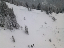
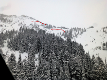
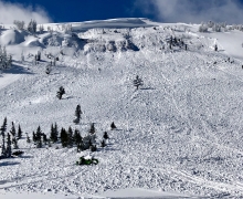
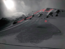
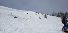
Heavy snowfall brought 17-20” south of Big Sky and near West Yellowstone, 14” near Cooke City, a spotty 3-8” near Bozeman and Big Sky. An inversion near Bozeman has low elevation temperatures below 0F. Temperatures are 20s F elsewhere. Winds are southwest at 20-30 mph with gusts over 50 mph, and 10-25 mph in the Bridger Range. Temperatures will rise into the high 20s and winds will remain moderate out of the southwest. Snow will continue through the day, increasing overnight. By morning the mountains will have 12-18” of new snow near West Yellowstone and Cooke City with 4-8” near Bozeman and Big Sky.


Since yesterday the mountains received 20” of snow near West Yellowstone, 12-14” south of Big Sky and near Cooke City, and 4-6” near Bozeman and Big Sky. Temperatures this morning are negatives and single digits F near Bozeman, and teens to low 20s F elsewhere. Wind has been southwest at 20-30 mph with gusts of 40-50 mph, and 5-15 mph in the Bridger Range. Today, temperatures will be teens to low 20s F and wind will be southwest at 20-35 mph. Snow showers will continue and by morning the mountains will have 12-20” of new snow near West Yellowstone and Cooke City with 5-8” near Bozeman and Big Sky.

At 4 a.m. there is 6” of low density new snow at Lionhead and in the Bridger Range, and 2-4” elsewhere. Temperatures are single digits F this morning and will reach teens F today. Wind is west-southwest at 10-15 mph with gusts to 25 mph, and northwest near Cooke City. Today wind will be south-southwest at 10-20 mph with gusts of 30-40 mph this afternoon, and will shift east in the Bridger Range. Snow showers are expected through Tuesday with heavy snowfall possible this afternoon and tonight. By tomorrow morning 8-12” of new snow is likely.


This morning there’s no new snow to report and temperatures are in the single digits above or below zero F. Winds are blowing 15-25 mph out of the west-southwest with gusts in Hyalite breaking 30 mph. Today, skies will become mostly cloudy and temps will warm into the upper teens to low 20’s F. Winds will continue to blow 15-30 mph shifting to the west-northwest by this afternoon . Light snow develops this evening and the mountains will see 2-4” by tomorrow morning. A heavier shot of snow impacts the region tomorrow into Monday.
This morning there’s no new snow to report. At 5 a.m. temps range from the single digits above or below zero F and winds are blowing 5-15 mph out of the west-northwest. Today, highs warm into the teens F under partly cloudy skies and winds will remain light to moderate out of the west-northwest. No snow is expected over the next 24 hours.
The Bridger Bowl Cloud delivered yesterday, producing 21” of very light snow (2.5% density) since early yesterday morning. A trace to 2” fell elsewhere. Temperatures are in the single digits above and below 0F this morning. Winds were 10-20 mph out of the northwest to northeast yesterday, and have diminished overnight. Winds will remain light and generally northerly today. Temperatures will rise into the teens F and flurries will bring a trace of new snow.