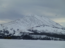
Advisory Archive
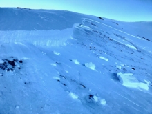
Since yesterday morning the mountains received 9” of snow near Cooke City, 6-9” from Big Sky to West Yellowstone, 4” in the Bridger Range and 2” in hyalite. Yesterday evening wind gusted 40-50 mph out of the southwest, and this morning wind shifted west to northwest at 5-15 mph. Today, temperature will decrease from mid 20s F this morning to teens F this afternoon. Wind will be northwest to northeast at 15-25 mph. Snow showers through tonight will deliver 6-8” to the mountains near Bozeman, Big Sky and Cooke City with 1-2” near West Yellowstone.


Since yesterday morning the Bridger Range received 9” of heavy snow. The mountains south of Bozeman and near Big Sky got 2-4” with 5” near West Yellowstone and Cooke City. Temperatures are in the low 20s F this morning and wind has been southwest at 15-25 mph with gusts to 35 mph. Temperatures will warm to the high 20s and low 30s F today. This afternoon wind will increase to 30-45 mph out of the west to southwest. Today expect steady snowfall in the southern mountains with more throughout the advisory area tonight. By morning, near West Yellowstone and Cooke City could get up to a foot of new snow with 4-6” near Bozeman and Big Sky.


Since yesterday morning, the mountains south of Bozeman picked up a trace to 1” of new snow. This morning, skies range from partly to mostly cloudy and temps are in the teens F. Winds are blowing 15-30 mph out of the west-southwest. Today, no real accumulation is expected and temps warm into the low to upper 20’s F. Winds will increase out of the west-southwest with ridgetop gusts pushing 40 mph by this afternoon. Light snow is expected across the forecast area this evening with 1-3” possible by morning. Sunday night into Monday looks promising for a heavier shot of snow.
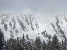
Over the past 24 hours the mountains near West Yellowstone and Cooke City picked up 5-6” of new snow while the mountains near Bozeman and Big Sky received 3-5”. At 5 a.m. it’s still snowing in the Bridger Range, but dry elsewhere. Temps range from the teens to low 20’s F and winds are blowing 10-20 mph out of the west-northwest. Ridgetop gusts near Bozeman and Big Sky are pushing 30 mph. Today, snow tapers off by mid-morning and skies will be partly cloudy by this afternoon. Temps warm into the mid to high 20’s F and winds will blow 10-20 mph shifting to the west-southwest. A weak storm will brush by the southern mountains tonight delivering 1-2” of snow to West Yellowstone and Cooke City.
At 5 a.m. the southern mountains and Lionhead area have 1-2” of new snow and Cooke City has 3”. Temperatures are near 20F and winds are southwest at 10-20 mph with gusts of 35 mph. Today will be cloudy with scattered snowfall, temperatures in the upper 20s and similar winds. By morning, 4-6” will fall in the southern mountains, including Cooke City, and 2-4” everywhere else.

Last night 1-2” of snow fell in the southern mountains, Lionhead area and Cooke City. Temperatures are in the upper teens and winds are west to southwest at 10-15 mph with gusts of 30 mph. A moist south to southwest flow will bring increasing clouds, winds averaging 20 mph and daytime temperatures into the upper 20’s to low 30s. By morning I expect 1-2” of snow in the southern mountains and Cooke City, and more falling tomorrow over our entire forecast area.
An inversion continues this morning with cooler temperatures (teens F) in the valleys and warmer temps (high 20s F) at ridgetops. Winds were light yesterday and there has been no new snow. Winds will remain light today and be generally southerly. Temperatures will rise into the high 20s and low 30s F. Snowfall will begin this afternoon in the southern mountains, with 1-2” of new snow by tomorrow morning. The next chance for snow in the northern mountains is Wednesday night.

An inversion continues this morning and temperatures range from teens F in the valleys to low 30s F at ridgetops. Yesterday temperatures reached the high 30s to high 40s F, wind was northerly at 5-15 mph, and there has been no new snow. Today will be mostly clear with temperatures reaching high 30s F and wind out of the west-northwest at 5-15 mph. The next chance for snow is late Tuesday for the southern mountains and early Thursday for the northern ranges.


This morning there is no new snow. Due to an inversion temperatures are high 20s to low 30s F at ridgetops and teens F in the valleys. Wind is 5-15 mph out of the north to northeast. Today, wind will remain 5-15 mph out of the north to northeast with temperatures in the high 20s to low 30s F under mostly clear skies. The next chance for snow is late Wednesday.
High pressure continues to dominate the weather pattern. As a result, strong temperature inversions exist across the forecast area. Currently, the top of Bridger Bowl is ten degrees warmer than the base area. At 5 a.m., mountain temps are in the 20’s F and winds are blowing 5-15 mph out of west-northwest. Today, clear skies and plenty of sunshine will allow temps to warm into the 30’s F and wind will stay light to moderate out of west-northwest. High pressure continues through the weekend.