Advisory Archive
Yesterday afternoon, light snow showers dropped a trace to 1” of snow in the mountains around Big Sky. The rest of the forecast area remained dry. At 5 a.m. temps range from the teens to low 20’s F under mostly clear skies. Westerly winds are blowing 5-15 mph with gusts in the Bridger Range breaking 20 mph. Today, temps warm into the upper 20’s to low 30’s F and winds remain light to moderate out of the west. There’s no snow in the forecast as far as the eye can see.


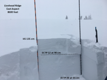
Last night a trace to an inch of snow fell in the Lionhead area. This morning mountain temperatures are in the low 20s F with south to southwest wind blowing 15-20 mph with gusts of 40 mph. Clouds in the southern mountains will clear this afternoon as high pressure brings sunny skies and above normal temperatures for the next 7 days. Today, temperatures will rise into the mid-30s F and winds will shift westerly to 10-20 mph.

This morning there is no new snow to report. Mountain temperatures are in the high 20’s and above freezing (34F) in the Bridger Range from an inversion. Winds are blowing south to southwest at 10-20 mph with gusts of 40 mph. Today will start cloudy and slowly clear with winds remaining moderate from the southwest. Temperatures in the north may reach 40F and stay near freezing elsewhere. West Yellowstone can expect an inch of snow tonight.
Yesterday morning the mountains picked up 1-3” of new snow before snowfall tapered off mid-day. Temperatures this morning are in the single digits to low teens F. Winds are blowing 10-20 mph from the southwest to west in the southern ranges and 15-30 mph with gusts up to 50 mph in the northern ranges. Today, winds will be from the southwest, decreasing slightly in the northern ranges and remaining light in the south. Temperatures will rise into the low 20s F this afternoon. No snowfall is expected today.

Since yesterday morning the mountains near West Yellowstone and Cooke City got 8-9” of new snow, the Bridger Range got a heavy half inch, and Big Sky got a trace. This morning, temperatures are in the teens F and wind is south to southwest at 25-35 mph with gusts of 45-70 mph. Today wind will shift to west-northwest at 35-45 mph. Temperatures will be teens to low 20s F and drop to the single digits F tonight. Light snowfall will continue this morning and the mountains will get 2-4” with 6” possible near Cooke City by tonight.


At 4 a.m. the mountains near West Yellowstone have 2-4” of new snow with 1” in the southern Madison Range and no new snow elsewhere. Temperatures are high teens to mid-20s F. Wind has been south-southwest at 25-35 mph with gusts of 40-60 mph. Today, temperatures will stay in the teens and 20s F. Wind will be southwest at 25-35 mph with gusts to 40 mph. Snow showers will continue to favor the mountains near West Yellowstone with 2-4” today and 3-5” overnight. By morning the rest of the mountains will have 2-4” near Big Sky and Cooke City, and 1-2” near Bozeman.
This morning there is no new snow, temperatures are high teens to mid-20s F and wind has been southwest-west at 10-20 mph with gusts to 35 mph. Today, temperatures will be in the high 20s to low 30s F with wind out of the south-southwest at 5-15 mph. This evening southwest wind will increase to 30-40 mph. Snow showers are expected early tomorrow morning and will favor the mountains near West Yellowstone. The southern ranges and West Yellowstone will get 2-4” by morning and the mountains near Bozeman, Big Sky and Cooke City will get a trace to 1” with more snow through tomorrow.


At 5 a.m. temps range from the teens to upper 20’s F under mostly clear skies. West-southwest winds are blowing 25-40 mph in the northern mountains and 15-25 mph in the south. Today, warm and windy conditions will continue. Highs will climb into the upper 20’s to low 30’s F and winds will remain moderate to strong out of the west-southwest. No new snow is expected over the next 24 hours.

Since yesterday morning, most mountain locations picked up a trace to one inch of new snow. At 5 a.m. temperatures range from the single digits near West Yellowstone to the low 20’s F near Bozeman and Big Sky. Winds are blowing 15-35 mph out of the west-southwest. Today, temps warm into the mid to upper 20’s F under mostly clear skies. Winds remain moderate to strong out of the west-southwest. No new snow is expected over the next 24 hours.

Under partly cloudy skies, mountain temperatures are near 10F. Strong west winds are blowing 20-30 mph and gusting to 45 mph in the northern ranges and 10-20 mph in the southern mountains. Skies will clear today and temperatures will rise into the upper 20s and drop into the teens tonight. Winds will be westerly and blow 20-30 mph in the north and 10-20 mph in the south. No new snow is expected through the week.