Advisory Archive
The mountains did not get any new snow since early yesterday morning. Wind was 5-15 mph out of the southwest yesterday, and is east-southeast at 0-10 mph this morning. Temperatures are single digits to low teens F this morning, and will be in the high teens to low 20s F today. Wind will remain light at 0-10 mph out of the southeast to east. Today will be partly sunny with a trace of snow possible this evening, then cold and dry the rest of this week.


Overnight the mountains picked up 3-4” of new snow. At 5 a.m. it’s snowing lightly and temps are in the teens F. Wind are blowing 10-20 mph out of the W-NW. Today, snow gradually tapers off and skies will become partly cloudy by this afternoon. Temps warm to the upper teens to low 20s F and winds will remain light to moderate out of the W-NW. No significant accumulation is expected tonight into tomorrow.


This morning skies are clear and there’s no new snow to report. Temps are in the teens and winds are blowing 5-10 mph out of the E-SE with the exception of Bridger Range where they’re blowing 15-25 out of the E. Today, temps will warm into the 20s F and winds will gradually increase and shift to of the south-southwest. Skies will become cloudy this afternoon as a weak storm system approaches from the south. By tomorrow morning the mountains will likely see 2-4” of new snow.
At 5 a.m. all the mountains except the Bridger Range are reporting snowfall. Big Sky to West Yellowstone has 3” with 1-2” in Hyalite and Cooke City. Mountain temperatures are near 20F and winds are 15-30 mph with gusts of 40 mph from the W-SW. Snowfall will add another 2-4” by tomorrow morning with Cooke City getting closer to 6”. Winds will remain the same and temperatures will rise into the low 30s under mostly cloudy skies. Thursday looks to be partly cloudy with moderate SW winds and temperatures hitting the 30s.
Since yesterday morning the mountains got 4-5” of snow near Bozeman, Big Sky and West Yellowstone, and 7” near Cooke City. At 4 a.m. it is snowing and temperatures are high teens to 20s F. Wind is 10-20 mph out of the west to southwest, and will shift to the north-northwest at 20-30 mph this morning. Temperatures will be in the 20s F today and drop to single digits tonight. Snow will continue through the afternoon with 8-12” possible near Bozeman, Big Sky, and Cooke City and 3-5” near West Yellowstone.


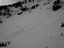
Since yesterday afternoon the mountains near West Yellowstone picked up 5-7” of new snow. The Bridger Range and mountains around Cooke City received 4-5” while the Big Sky area squeezed out 2-3”. This morning, it’s still snowing lightly and temps range from the teens to mid-20’s F. Winds are blowing 20-40 mph out of the W-SW. Today, temps will warm into the upper 20’s to low 30’s F and winds will continue to blow 20-40 out of the W-SW. There will be a slight break in precipitation today before a stronger storm impacts the area tonight and tomorrow. By morning the southern ranges and mountains around Big Sky will likely see 6-8” of new snow while the mountains around Bozeman will see 4-6”. Temps will drop into the teens tonight and winds will remain moderate to strong out of the W-SW.
The mountains have not gotten new snow over the weekend. Under partly cloudy skies temperatures are in the low 20s and winds are west at 15-30 mph. Sunny skies are forecasted through Wednesday with mountain temperatures in the 30s and light southwest winds. On Thanksgiving expect partly cloudy skies and cooler temperatures with an increasing chance of snowfall on Friday and Saturday.
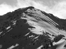
Since yesterday morning the mountains near Bozeman and Big Sky picked up 5-7” of new snow while the mountains around West Yellowstone and Cooke City received 2-3”. During the storm winds blew 20-35 mph out of the W-NW, but decreased overnight and are currently blowing 5-10 mph out of the N-NE. The exception is the Bridger Range which has ridgetop winds blowing 10-15 mph from the due east. Temps this morning range from the single digits in the north to low teens in the south. Today, skies will be partly cloudy, winds will blow 5-15 mph out of the N-NE, and temps will warm into the upper teens to low 20s F. A building ridge of high pressure will produce nice weather through the weekend.

This morning temps range from the low 20s to low 30s F under mostly clear skies and winds are blowing 15-25 mph out of the W-SW. Nice weather continues today with plenty of sunshine and highs climbing into the 30s to low 40s F. Winds will increase this afternoon gusting upwards of 30 mph from the W-SW. Dry and breezy conditions continue through tomorrow, but a good storm is forecasted to deliver heavy snow on Friday.
In the last 24 hours the Bridger Range picked up 5” of snow while the mountains south of Bozeman to Big Sky and Taylor Fork got 1-2” and only a trace around West Yellowstone and Cooke City. Under clear skies mountain temperatures dropped to the single digits to zero F and westerly winds are blowing light at 5-15 mph. This week a dry high-pressure ridge will bring sunny skies, increasing winds and daytime temperatures reaching into the 30s. Our next chance of snow is Friday.