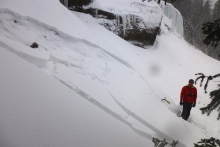
Advisory Archive
Overnight a weak weather disturbance dropped a trace to one inch of snow in the northern Gallatin Range and mountains around Big Sky. At 4 a.m. temperatures are in the 20’s F with the exception of Cooke City and West Yellowstone where temps are in the teens F. Winds are blowing 15-25 mph out of the WSW with localized gusts in the 40’s. Today, temperatures will warm into the 30’s F under partly to mostly cloudy skies. Winds will continue to blow 15-25 mph out of the WSW with stronger gusts along the ridgelines. Warm and windy conditions will continue through tomorrow. A significant weather change is on the horizon with snow and cold temperatures arriving Wednesday night into Thursday.
Over the past 24 hours the mountains around Cooke City picked up 1-2 inches of new snow. This morning temperatures are in the mid to upper 20’s F with the exception of Cooke City and West Yellowstone where temperatures are in the low teens F. Today, expect windy and warm conditions under partly to mostly cloudy skies. Temperatures will climb into the 30’s F and winds will crank out of the WSW blowing 20-30 mph with localized gusts in the 50’s. Hyalite weather station in the northern Gallatin Range is currently recording gusts upward of 60 mph. There is a slight chance for mountain snow showers this afternoon, but no major accumulations are expected.

Over the past 24 hours the Bridger Range picked up four inches of new snow while all other areas received 1-2 inches. Temperatures this morning were mostly in the mid to high teens F with the exception of the West Yellowstone area where temperatures are in the single digits F. Winds are blowing 10-25 mph out of the WNW except in the Bridger Range where ridgetop gusts are reaching into the 40’s. Today, temperatures will warm into the mid to upper 30’s F under partly cloudy skies. Winds will continue to blow 10-25 mph out of the WNW. Little to no precipitation is expected over the next 24 hours.


Temperatures this morning were mostly in the mid to high teens F with winds blowing 10-15 mph from the W and SW gusting to 20 mph. Today will be cloudy and some snow will fall but only an inch or two will accumulate. Temperatures shouldn’t warm much and winds will shift a little through the day towards the NW blowing 10-15 mph gusting 20-30 mph.
This morning most places had temperatures in the teens F. Winds were blowing stronger near Bozeman and less so further south. W and SW winds near Bozeman were blowing 20-30 mph. Near West Yellowstone and Cooke City winds were blowing 10-15 mph. Today will have more sunshine and temperatures approaching 30 F near Bozeman with winds from the W and SW blowing 15-30 mph. Further south temperatures will be in the mid to low 20s F and winds will be a little calmer.

The Bridger Bowl Cloud was in full force yesterday and dropped a total of 26 inches! Put the kids in daycare, call in sick, skip school and shred. This is why we live here, right? All other mountain ranges picked up 2-4 inches yesterday. Winds are still blowing at 20-30 mph, but the direction has switched from west to southwest. This morning is clear with mountain temperatures in the single digits, but this afternoon temperatures will rise into the 20s under partly cloudy skies. Winds will continue to be moderate out of the southwest and no precipitation is expected in the next 24 hours.

I did a double take when I looked at my thermometer in Bozeman this morning. It read 18 degrees, thirty degrees warmer than a couple days ago--almost t-shirt weather! Mountain temperatures are still chilly with minus 5-10F around West Yellowstone and Cooke City; 5-10F elsewhere. At 6 a.m. it’s snowing in the mountains with 2-4 inches falling so far. Winds picked up yesterday and are currently blowing westerly at 20-30 mph and gusting into the 40s. Snowfall will end this afternoon and winds will taper off tonight. Another 3-6 inches will fall, but I expect double that in the Bridger Range given the favorable moist, northwest flow.

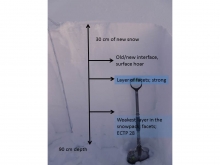
Over the past 24 hours a trace of new snow fell over most mountain locations. At 4 a.m. temperatures remain frigid. The mercury is reading -20 F in the mountains around Cooke City and West Yellowstone and -10 to -15 F elsewhere. To make matters worse, westerly winds are blowing 15-25 mph with gusts in the 30s. Although temperatures will actually warm above zero today, strong winds will continue to make it dangerously cold. Skies will be partly to mostly cloudy and there is a slight chance of mountain snow showers later this afternoon. The good is – temperatures will gradually warm throughout the week. Tomorrow looks to be a much warmer day with a good possibility of snow. The mountains could pick up 4-6 inches by Wednesday morning.
Overnight the mountains around Cooke City and West Yellowstone received 1-2 inches of new snow. The rest of our advisory area remained dry. This morning, cold temperatures continue with most locations ranging between -5 and -10 F. Currently, winds are blowing 5-10 mph out of the WNW with the exception of Big Sky where winds are blowing 10-20 mph. Today, temperatures will struggle to climb above zero degrees F under partly to mostly cloudy skies. Winds will increase slightly throughout the day blowing 10-15 from the WNW. Even light to moderate winds can create dangerous wind chills with these frigid temperatures. There is a slight chance for mountain snow showers this afternoon and evening. No major accumulations are expected.

Cold continues with mountain temperatures around -10 F most places this morning. Valley temperatures were coldest near Bozeman and the Bridger Range around -20 F. For comparison, it was -18 F at the South Pole this morning. Winds increased last night but eased a little this morning blowing 3-8 mph from the south gusting 10-15 mph. Today will have some sun and a few clouds near Bozeman and a chance of snow and more clouds near West Yellowstone. High temperatures should remain below zero F. Winds will decrease and become more easterly today.