Advisory Archive

The mountains of our advisory area have 3-4” of new snow this morning with 1” in the Northern Gallatin Range. Temperatures are in the mid-teens F with 25-30 mph winds from the west to southwest except in the Bridger Range where they are 10-15 mph. Today, temperatures will remain in the mid-teens F before falling this afternoon and the wind will be 15-20 mph from the west. Light snowfall will continue today intensifying tonight and the mountains will have 4-6” new by morning with 6-8” in the Cooke City area.


Since yesterday evening wind has been 15-30 mph out of the south-southwest with gusts of 45-55mph. This morning temperatures are single digits to low teens F. No snow has fallen in the last 24 hours. Today will be mostly cloudy with temperatures in the teens to mid-20s F and southwest wind at 15-30 mph with gusts of 35-55 mph. Snow is expected tonight and tomorrow with 2-4” possible by tomorrow morning.


This morning there is no new snow. Temperatures are single digits to low teens F near Bozeman and Big Sky, and below zero F near West Yellowstone and Cooke City. Yesterday in the Bridger Range west wind was 30 mph with gusts to 45 mph. Overnight, throughout the advisory area westerly wind was 25 mph with gusts of 30-45 mph. Today will be partly cloudy with temperatures reaching low teens to low 20s F. West-southwest wind will be 10-25 mph this morning and will increase to 30-45 mph this afternoon. The next round of snow is expected tomorrow night.
A trace to an inch of new snow fell yesterday morning. Winds are light out of the west and northwest. Temperatures are chilly this morning: negative single digits to negative teens F. Under sunny skies today, winds will pick up slightly in the northern part of our advisory area and stay calm in the south. Temperatures will rise into the positive single digits and teens F. The next snowfall is forecast for Monday night.


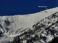
The mountains around Cooke City have 9” of new snow, with 4-7” near West Yellowstone, and 2-4” near Bozeman and Big Sky. Winds have been 15-20 mph out of the west and southwest with gusts as high as 60 mph. Winds will calm dramatically this morning and shift to the north. Temperatures in the single digits this morning will fall throughout the day as a cold front moves through. Light snowfall today will bring 1-3” near West Yellowstone and Cooke City with only a trace around Bozeman and Big Sky.


Since yesterday morning the mountains around Bozeman and Big Sky got 1-2” while the higher elevations outside West Yellowstone and Cooke City received 3-4”. Wind increased last night from the west to southwest averaging 25 mph with gusts reaching 48 mph. These strong winds will continue today before tapering tonight. At 5 a.m. temperatures are in the single digits and will warm into the teens. Today will be snowy and by morning 2-3” will fall around Bozeman and Big Sky with 3-5” in the southern ranges including Cooke City.

In the last 24 hours it snowed 3” in the Bridger Range, a trace to an inch around Hyalite and Big Sky, and 2” in the mountains around West Yellowstone and Cooke City. Wind is blowing west to south at 15-20 mph with gusts of 35 mph. Mountain temperatures are -2F to -8F. Today, temperatures will rise into the positive single digits with westerly wind blowing 20-30 mph. Scattered snowfall will drop 2-4” in the southern areas and 1-2” in the mountains around Big Sky and Bozeman by tomorrow morning.


The mountains around West Yellowstone and Cooke City received 2-3” of new snow yesterday with 0-1” in the mountains near Bozeman and Big Sky. High temperatures reached the single digits to low teens F before plunging back to the single digits below 0 F and winds were 10-20 mph from the west to northwest. Today, temperatures will be in the single digits above 0 F with 10-20 mph wind from the west. By morning, there will be 1-2” of new snow in the mountains across the advisory area with more tomorrow.


In the last 24 hours, the mountains around Cooke City and West Yellowstone along with the Southern Madison and Southern Gallatin Ranges received 7-10” of new snow with 5-8” in the mountains around Bozeman and Big Sky. Temperatures are in the single digits to low teens F with south to southwest winds blowing 20 to 25 mph. Today, the thermometer will not change much with highs in the single digits to low teens F, winds will be 5-15 mph from the southwest to northwest and by morning, the mountains around Cooke City and West Yellowstone will have another 2-4” with a trace to 1” everywhere else.

Since yesterday the mountains received 7-9” of snow near West Yellowstone and in the southern Madison range, 6” near Cooke City, 1” in Hyalite and zero near Big Sky and the Bridger Range. Overnight, temperatures rose to the high teens and low 20s F, and wind was south-southwest at 10-25 mph with gusts of 30-50 mph. Today, temperatures will drop through the teens into single digits F by tonight, and wind will be southwest at 15-25 mph with gusts of 30-45 mph. Snow will continue near West Yellowstone and Cooke City and begin in Big Sky and Bozeman later this morning. Another 4-6” of snow is possible throughout the advisory area today.