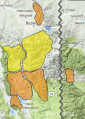
Advisory Archive
Since yesterday morning Cooke City has received 3” of new snow, the only area with accumulation. Wind is strong and steady out of the west-southwest at 15-25 mph with gusts of 55 mph. Mountain temperatures are near 10F and will warm to 20F. Today, wind will continue and 1” of snow will fall around Cooke City and West Yellowstone. Tonight will be clear and cold throughout southwest Montana. More snowfall is expected later in the week.


Since yesterday afternoon the mountains received 6-10” of new snow in the Bridger Range, Cooke City and south of Big Sky to West Yellowstone. Hyalite and Big Sky received 5-8”. This morning, snowfall is tapering, temperatures are teens to 20s F and wind is southwest at 10-20 mph with gusts of 25-35 mph. Today temperatures will reach low to mid-20s F. This afternoon southwest wind will increase to 20-35 mph, and possibly stronger in the northern ranges. A few light snow showers are possible today with the next round of significant snow tomorrow morning near Cooke City, and throughout the forecast area later this week.

This morning there is no new snow. Temperatures are teens to low 20s F. Wind has been out of the west-southwest at 10-20 mph with gusts to 35 mph. Today temperatures will be in the 20s F. Wind will be west-southwest at 10-20 mph, and will increase to 20-30 mph with the arrival of snow showers this afternoon. Snow will last through tonight with 4-8” possible by morning.

There is no new snow to report. Temperatures are in single digits and teens F. Winds are 15-25 mph out of the southwest and west with gusts of 40-50 mph. Temperatures will rise into the teens and 20s F with mostly sunny skies. Moderate west and south winds will continue. Another round of snowfall is expected to begin tomorrow.

Since yesterday morning, there are 18” of new snow (with 1.9” snow water equivalent) in the Lionhead area, 8-10” (0.8-1.1” SWE) in Taylor Fork and Cooke City , and 5-8” (0.2-0.4” SWE) near Bozeman and Big Sky. Winds were 20-40 mph with gusts of 40-75 mph out of the south and west yesterday. Overnight winds shifted to the north and west and decreased dramatically, but are still gusting up to 30 mph. Temperatures are in the single digits and teens F this morning. Winds will remain moderate out of the north and west today. The bulk of the snowfall is over, but another inch or two may fall this morning as the storm passes.

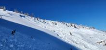
By 6 a.m. the mountains around Bozeman had 1” of new snow, 8” at Big Sky, 3-6” south of Big Sky to West Yellowstone and Island Park, and a whopping 17” outside Cooke City. Temperatures are in the teens F and wind is blowing south to west at 15-25 mph with gusts of 50 mph. Today will remain windy and gusty. By tomorrow morning the southern mountains are poised to get 15-20” of new snow with 5-10” everywhere else. About half the snowfall amounts will fall today and half tonight.
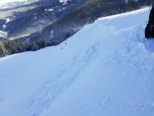
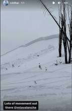
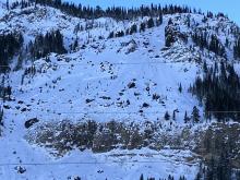
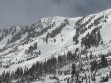
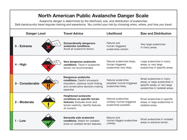
We are on the cusp of issuing an Avalanche Warning (a HIGH danger on all slopes) for the mountains around Cooke City, West Yellowstone and Island Park.


At 5 a.m. the mountains around Bozeman and Big Sky received 1” of new snow while West Yellowstone and Cooke City picked up 2”. Temperatures are in the low single digits F and wind is averaging 15-30 mph with gusts of 50 mph out of the W-SW. A strong, moist, southwest flow will bring snowy weather through Friday. By morning I expect 1-2” around Bozeman and Big Sky and 6” in the southern mountains including Cooke City.

This morning, mountain temperatures are in the single digits above and below zero F with 5-10 mph winds from the west to northwest. There is no new snow. Today, temperatures will peak in the single digits above zero F with 5-15 mph wind from the west. The southern portions of the advisory area will get a trace of new snow tonight as the leading edge of this week’s storm moves into the area.


This morning, mountain temperatures are in the single digits to low teens F and yesterday’s strong winds calmed and are currently 10 to 20 mph from the west to northwest. In the last 24 hours, the mountains around Cooke City, West Yellowstone and the Northern Gallatin Range received 7-12” of new snow with 2-3” in the Bridger Range and near Big Sky. Temperatures will warm into the high single digits to mid-teens F with west winds 5-15 mph. The southern portions of our advisory area will receive an additional 2-3” of snow by morning with a trace to 1” in the northern ranges.


Yesterday morning the mountains near Bozeman and Big Sky received 3-4” of snow and 1-2” fell elsewhere. Overnight, west-southwest wind increased to 15-25 mph with gusts of 30-40 mph. Temperatures are low teens to low 20s F this morning. Today, temperatures will reach high teens to 20s F, and wind will be westerly at 25-40 mph with a few snow showers. More snow is expected tonight with 1-2” near West Yellowstone, 3-6” near Bozeman and Big Sky, and 6-9” near Cooke City by tomorrow morning.

